(Use this page to print out the hike. Click the back button to go back to the webpage - www.berkshirehiking.com)
Cats Rock opens up just off the Appalachian Trail in Pawling, New York presenting the hiker with a beautiful sprawling overview of the valley and countryside below (at the very bottom of this page is a panoramic photo from Cats Rock). It's not a jaw dropping view with endless panoramas but a gorgeous, relaxing spot that invites a quick snooze or meditation. Cats Rock is an ideal destination if you want a moderate hike, that isn't too far or long, that rewards you with a nice ending spot. You can of course create a 7 mile round trip more strenuous hike and make a day out of it by parking at the Metro North Appalachian Trail train station off of Route 22 in Pawling and hike in from there. If you live in New York City or along the Metro North line you don't even need a car to get to the trail! Running out of Grand Central station, Metro North as created a cool little wooden station specifically made for the Appalachian Trail. It's a tiny thing as if from a bye gone era. It's fun just to be dropped off in seemingly random manor for the sole reason to hike. You'd hop off the train, cross the tracks, and head south on the Appalachian Trail all the way to Cats Rock. Very cool. If you time yourself just right, you can hike off in the morning and make it back in time for the train back. Just don't delay or you'll miss the train! Or you could hike in to Cats Rock, camp out at the Appalachian Trail back country site called Telephone Pioneer Shelter (with neither telephones or pioneers so not sure where the name comes from), then back to the train the next day.
If you can handle a 7 mile round tripper, go for that option from the train station (a couple of spots to park in a grassy lot but also just about a hundred feet up Route 22 are large paved rest areas - with no facilities - so parking is never an issue if the little grassy lot is crowded or too muddy or icy in winter. The trail from the train station is flat for about a half mile. The first section can be VERY muddy and mucky as it passes through a wetlands section but should be fine if there hasn't been a lot of rain or snow melt. In spring and summer the amount of songbirds and migratory birds is absolutely amazing. You'll see birds you've never seen and hear songs you've never heard...or maybe some that you haven't seen/heard since you were a kid. Tall grasses and thick bush envelope the trail so it might be tough to see some of the birds but you'll know they're right next to you. A nice boardwalk, wooden plank system, allows the hiker to nestle into the section and also keep the feet dry. It's worth stopping in here just to be still and look or listen for the birds. (NOTE: dusk or dawn during late summer the mosquitos can be quite numerous over this short stretch of trail do to all the pools of water and general soggy conditions).
The initial wetland section doesn't last too long and soon you're in a classic hardwood forest with tall, cool canopy. The forest hike meanders up at a constant rate but it's never steep. It can be quite rock with tree roots so just be careful in certain section. It's a nice contrast from the open air wetland section that warms you up. It's quiet in here with the exception being some of those beautiful birds using the forest to zip in and out of down to the wetland. Chipmunks, with their high pitched alert system, buzz around in fast-forward motion or freeze solid blending into the forest floor. If you've got a good eye for nature you might spot an owl or hawk perched high in a pine tree or hardwood looking out over what is likely a nice domain for them.
Emerging from the forest you'll be a bit higher up and ready for the next section of trail. It's a gorgeous open field hike. This trail brings radical changes and they're welcome changes. Only in this region can you can a hike like this. It may not be grand or immense, but the variety in short distances can't be matched elsewhere. Wetlands, into forest, emerging into open fields. In spring and summer the fields are magical. Wildflowers, berries, birds, butterflies, dragon flies, are always on full display. Waist high grass, blue skies, fluffy clouds...it's on those days this spot is postcard perfect...well, much better than a postcard! During fall foliage the scene is cinematic. You just have to see it for yourself rather than describe it to you. It's very fortunate that people had the forth sight and will power to put aside places like this. It's old farmland given back to nature instead of a developer to plop down cookie cutter suburbia in order to make a quick profit. You won't see many far off homes during the open field stretch and some short patches you may as well be in Kansas.
Appalachian Trail is worn well and the white hash marks easily spotted so there's no problem following it along or being overwhelmed by the wild growth of a field left to it's own. But there are sections where the field grows tall and right up against the trail. If you're wearing shorts in summer just be aware of that. Definitely want to check for ticks (Lyme Disease) when you finish the open field sections and when you're back home. And don't be alarmed if a cow or two suddenly appear. There's still a farm nearby and they wander up to the outer boundaries of the farm which border the trail section. Cows are cool...so no worries as far as "when animals attack" but of course trying to jump on one or bother it is not something you'd want to do!
As you hike down the far end of the fields you'll soon come upon a road and near some homes. An amazing, majestic oak tree (pictured left) marks the spot where the next section of trail begins across the road. From here it's not too far up to Cats Rock but after an initial flat section that has some wet spots the trail rises up fairly steady and steep but it's never an extreme incline. You'll definitely get a workout though so if you're feeling tired or hungry you may want to turn around and head back to the car or train station. Or perhaps recharge a bit under the tree with food and water to prepare for the hike up to Cats Rock.
If you're just looking for a moderate hike to Cats Rock then you can drive into this spot, bypass all the open field and train station section, and park at the oak tree for the hike up. It's about a mile up through a dense hardwood forest. It's your standard "just keep going" and you'll get there hike up. Nothing too major but can't say it would be easy for a beginner or those who day hike occasional. Once in awhile school buses pull up and take some kids up so that should show that it isn't considered a difficult hike.
A nice distraction near the top would be Telephone Pioneer Shelter. You can check out the back country camping site that so many Appalachian Trail hikers stay at. There's a main wooden cabin lean-to with several areas to pitch a tent. Not sure why the name and perhaps not a the best to have "telephone" in the name since there's public phone within miles of any direction. There's a privy (outhouse) if you need to use the restroom. You're at an elevation of about 900 feet with a couple hundred more to go so Cats Rock is perched up over the valley at about 1,000 feet above sea level though the hike from road to Cats Rock is only a few hundred feet elevation gain. The shelter is a nice one so if you're thinking of trying back country camping this would be a great choice. (for detailed info on the shelter and trail visit the New York - New Jersey chapter of Appalachian Trail Mountain Club, http://www.amc-ny.org. They may even have a group hike heading up to Cats Rock.
After checking out the shelter, head back up beyond the little stream area and back on to the white blazed Appalachian Trail. The trail heads up then begins to bend to the right as the trail summits the hill top. As you crest the hill (mountain?) the trail straightens and flattens out again. If you're hiking with your head down, deep in thought or just breathing hard trying to get to the top, you could walk right by Cats Rock overview. A small half loop side trial justs off to the right of the Applachian Trail and between some thick bushy patch and into the open air rocks and magnificent view of Cats Rock. Just keeping an eye out for the side trail and some common sense, since suddenly you should see some rocks and open air space off the trail, will get you there just fine.
The view is a 180 degree eastern view. You're looking out over Wingdale/Pawling, New York and out over into Kent/Sherman/northern New Milford, Connecticut. It's a beautiful spot to sprawl out and relax. Some large condo complexes are visible in the extreme right (southern) views but mostly you can see how this protected land offers up a classic rural scene that wouldn't have been much different 75 years ago. At the very bottom of this page is a panoramic view taken on a cloudy day. It's several photos pieced together but gives you some idea.
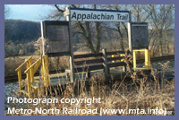 Directions: If you plan to take a long hike, or if you are coming by train only, you can start at Metro North's Appalachian Trail stop in Pawling, NY. Visit MTA's A.T. web page to get times, schedules, info and pricing. For those of you used to buying tickets at the stations along Metro North there are NO TICKET MACHINES at the Applachian Trail stop. It's almost a 70 mile train ride from Grand Central and takes a little less than 2 hours. For those parking their cars and hiking in, the station is right off of Route 22, and 1/4 mile north of Hurds Corner. It's tricky to see as it's just a little dirt/grass driveway and the small wooden station is hard to spot from the road. If the tiny space for parking is filled or too muddy you can park just up the road in one of the paved rest stops off of Route 22 and walk the few hundred feet back down to the A.T. train station. If your curious or for future reference, the A.T. crosses Route 22 and heads north towards Connecticut through the Pawling Nature Reserve and rest of New York state until it meets up with Connecticut.
If you just prefer a moderate hike and to scramble up for the views at Cats Rock then a very short distance south of the Appalachian Trail train station you'd go west on River Road and follow it until it ends at NY Route 20, also known locally as West Dover Road. Take a right onto West Dover Raod and drive slowly until you eventually will come upon the massive oak tree and white hash marks of the Appalachian Trail. Park in the dirt cut out off the road at the tree. Parking along the street is probably okay if there happens to be several cars taking up parking space. Across the road from the tree the Appalachian Trail disappears into the forest again and if you look up and to the right of the mountain you can see the rocky outcrop of Cats Rock way up high from the road parking.
© Berkshire Hiking 2006