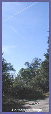
Housatonic
Range Trail is a 6.2 mile
footpath that starts in
Gaylordsville, CT. and ends at the
top of Candlewood Mountain in New
Milford. It's part of
Connecticut's Blue Trail system
and is maintained by a dedicated
group of volunteers. I hiked
the northern section
which begins off Route 37 in
New Milford and ends at the top of
Candlewood Mountain (902 feet).
Although I had driven pass
the trail head many times
throughout the years I never
considered hiking there because I
assumed that developers probably
had bought up the
choice woodland property that
is so close to Candlewood Lake and
Route 7. Suburban
neighborhoods, mobile home park,
rush hour type traffic,
McMansions nearby..."that trail
head must be some old thing that
people used 15-20 years
ago". I was
wrong. Housatonic Range
Trail is a great hike with
some cool spots that will capture
anyone's imagination.
When you park 4 feet off busy
Route 37 in a spot that looks like
you shouldn't be parking there and
look around at the houses and
bustling atmosphere, you think,
"this can't be a good place to
hike". And the first few
hundred feet of woodland hike
won't change that
impression. You'll feel like
your trespassing through a few
backyards because the trail makes
it's way pass a few homes before
heading out into more tranquil
surroundings. But soon
you'll find yourself in an
environment that offers great
views of the valley below,
changing landscapes, large rock
formations, and dense
woodlands. And Housatonic
Range is a challenging hike as it
just keeps rising, slowly but
surely, along the eastern face of
Candlewood Mountain and eventually
on up to the peak. The
first part of the hike makes it's
way through pine and hardwood
forest, skirting the property of a
few homes.
It soon spills out into a small
field that offers a nice
view of the valley
below; utility lines run through
here and create the field.
On the far side of the
field you re-enter the woods and
begin to distance yourself from
the hustle and bustle of Route
37 and 7 traffic. The
trail rises quickly and meanders
along the side of Candlewood
Mountain parallel to Route 7.
As you proceed, tall pine
trees and majestic hardwoods
rise above you and create a nice
canopy. Squirrels,
chipmunks, and birds of all
kinds will keep you company and
if you have a keen sense of
what's around you, turkey
vultures, hawks, deer, and other
forms of wildlife can also be
seen.
One
thing that makes Housatonic
Range so interesting are the
vast amount of large rock
formations. Some of these
are huge and all are
fascinating. You'll have
ample opportunity to scramble
around and at one point you can
climb up and through a grouping
of large rocks. A
tunnel
of sorts is formed and you'll
climb up it using hands and
feet, eventually emerging on
top of the huge rock
formation. It's a nice
highlight and adds some fun
and excitement to break up the
trail experience. It's
a very short climb of 10 feet
or so but at the top just keep
your concentration as a fall
here could result in a bad
injury. A short
distance after the rock climb
you'll notice the trail goes
left or straight. Go
straight, as the left option
is actually a by pass around
the rock climb for those who
choose not too climb through
the rocks. (For some, the rock
tunnel could be a little
claustrophobic or too
challenging. This side
trail is a nice alternative.)
As you continue on, the trail
begins to climb steadily and
the terrain is a mixture of forest
and rock.
Western views of the valley
below are plentiful and
eventually you'll make your
way over to Kelly's
Slide.
There are 2 options
when presented with the
sign to Kelly's Slide.
Go left to Kelly's
Slide or go straight to
the top of Candlewood
Mountain. You could
go left to Kelly's Slide
and from there up to the
top of Candlewood but if
you're feeling a little
tired, Kelly's Slide is
your best bet. The
top of Candlewood Mountain
is nice with a peaceful
setting, but the views are
very obstructed by all the
trees (this would be a
perfect spot for an
observation tower...maybe
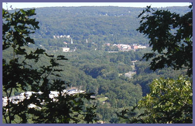
someday!) The view
from Kelly's Slide
is fantastic (Housatonic
River valley, downtown
New Milford, surrounding
countryside and
mountains) and the giant
rock that makes up the
slide is quite
impressive.
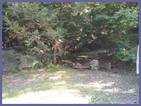
Another reason for
going down to Kelly's
Slide is a small cave
spot that was created by
the jumble of large
rocks. On your way
to Kelly's Slide you'll
see a side trial with
red/orange markings
heading down under the
rocks. It's a
short distance to the
cave area and the cave
itself didn't appear to
be too large...although
it could be more
extensive than I realize
since I didn't explore
this region too much.
(Use common
sense around the cave
and Kelly's Slide
sections. There are
some areas that could
be a little dangerous
with the possibility
of falling a long
distance or onto
rocks. And if you've
got children with you
keep a close eye on
them. These are
fun places to explore
and it's easy to loose
track of where you
are.)
If you take your time
and explore this portion
of the Housatonic Range
Trail you'll see some
amazing sites provided
by Mother Nature.
It's a great place
to check out. If
you're ready for more
after Housatonic Range
follow the blue trail
signs across Route 37 as
you'll walk a short
distance along the road
and eventually back into
the woods. The trail
heads north to
Gaylordsville. Here
you'll discover more
rock formations and deep
forests. And there's a
side trail to Tory's
Cave.
 Directions:
At the
intersection of Routes 7
and 37 just north of New
Milford center, take
Route 37 as it heads
west to New Fairfield. A
half mile later you'll
see Candlewood Mountain
Road on your left. Do
not turn onto the road
but just pull off the 37
onto the tiny dirt/rock
parking area at the
intersection of 37
Mountain Road. Look into
the woods and the blue
trail marker and path
will be clearly visible.
If you drive pass the
mobile home complex,
you've gone too far.
Directions:
At the
intersection of Routes 7
and 37 just north of New
Milford center, take
Route 37 as it heads
west to New Fairfield. A
half mile later you'll
see Candlewood Mountain
Road on your left. Do
not turn onto the road
but just pull off the 37
onto the tiny dirt/rock
parking area at the
intersection of 37
Mountain Road. Look into
the woods and the blue
trail marker and path
will be clearly visible.
If you drive pass the
mobile home complex,
you've gone too far.
Printable
version of the
Housatonic Range page
|