According to The Nature
Conservancy, Jug
End State Reservation
in Egremont, MA is one of the last
great places...and you'll get no
argument from me. It's fortunate
for us that groups like this
aggressively seek to preserve
natural treasures. Otherwise, this
area would have gone the same
route as surrounding
lands...suburbia. Actually, Jug
End is located in a very
picturesque part of southwestern
Massachusetts and suburban sprawl
isn't too bad around these parts.
So by preserving this land and
making it accessible to all,
hikers can hop out of their car
and disappear for a while into a
serene natural environment.
Like many of the hikes in and
around the Taconic Plateau region,
Jug End gives the impression that
you are far away from the hustle
and bustle of everyday life. Hike
Jug End on a crystal clear day and
you should come away feeling
refreshed. It's one of those
places where you can almost feel
the clean air. The open field
views are great and the forest
hike that follows along a
cascading stream is quiet and
peaceful. You'll even get a taste
of the past when you stumble upon
the old furnace that must have
been a part of an old milling
process.
Jug End Trail Loop can be hiked
within an hour or two depending
upon your pace. You just follow
the trail markers (blue triangles
with a picture of an acorn) that
are posted on trees at regular
intervals. With the exception of a
few small areas, the trails are
well maintained and clearly marked
so you shouldn't have any problems
finding your way around. For the
most part the terrain is flat but
the farther back you go the more
the trail rises up. So if you're
not looking for a workout or if
you hike alone and don't like to
be out in the woods then just
explore the beautiful fields and
mountain views to the left or
right of the main entrance area.
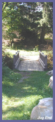
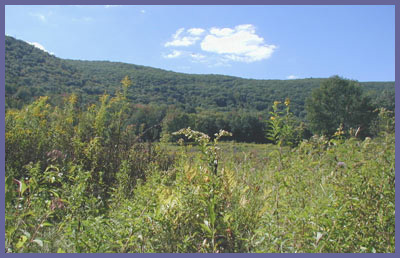
If you intend to do the trail
loop, start out by going right
from the parking lot (heading
west). You'll cross over a
footbridge that spans a nice
stream and then head out towards a
great open field teaming with wild
flowers and a nice mountain scene
that frames out the view
perfectly. If you're into
photography or painting, this is
your spot to explore (during the
fall foliage season, this spot
would be ideal to paint or
photograph). In the distance you
might see a tractor or two tending
to Indian Line Farm. According to
The Nature Conservancy web page,
this farm has historical
significance and is supported by a
community of farmers (visit
The Nature Conservancy page).
Take your time in this region
before heading off into the
forest. In summer take notice of
the frantic activity of birds, bees,
dragon flies, butterflies,
etc. A ton of wild flowers,
bushes, and tall grasses
create a perfect world for
them and if you don't take the
time to notice that microcosm
world you'll miss out on a
lot.
A short distance after the
open field area the trail
makes its way into the woods.
Immediately you are
transported into a completely
different environment. The
tall hardwoods and pine trees
create a cool, dark cover and
the trail begins a slight but
steady incline into the
forest. A small stream
parallels the trail and even
during drought conditions it
continues to flow and provide
perfect conditions for frogs,
toads, and insects to thrive.
The trail follows an old
utility road for quite some
time and can become muddy if
it's been raining. Muddy pools
emerge so watch your
step...not only wouldn't you
want to step into a mess, you
wouldn't want to step on one
of the toads/frogs
that seem to love these
muddy playgrounds.
Depending upon your pace and
if you stop to investigate
various things, 15-30
minutes later you'll come
upon an old furnace that
seems to be a remnant from
by a gone era. Given that
the stream flows down it's a
good guess that it's part of
an old milling process. It's
here that you need to go
left in front of this
furnace and not straight in
order to stay with the loop.
You could follow the trail
straight if you wanted to
investigate what's up ahead
but you're on your own from
that point on. I hiked up
until I came across a
compound/house that seemed
deserted but I didn't
venture to close since I
couldn't tell if it was
owned by someone who really
likes to get away from it
all! The utility road kept
going beyond this area but I
turned back.
But taking a left at the
furnace and following Jug
End Loop will eventually
take you back to your car.
Along the way you'll
continue to hike through the
dark forest canopy but
eventually you come out into
a spectacular open field
scene. One of the best open
field views listed on this
site. The field is teeming
with life during the
summertime and the bees are
so numerous pollinating the
abundant wild flowers that
you can actually hear a
large humming made by all
their wings. At first it can
be a little disconcerting
since we all associate that
noise with a mad swarm. But
there's just so many bees
that they can create quite a
noise. I must have walked
right over/through hundreds
of individual bees and they
were too busy to care about
my presence. The tall
grasses and underbrush also
provides nice cover for
birds of all types and
you'll surely flush out more
than a few as you hike
along. The trail stays close
to the edge of the forest
and you look down into the
field which is bounded on
the far side by the forest
you initially walked
through. Then rising up are
some nice mountains that are
completely covered with
trees. With the exception of
a radio tower on one of
these mountains, there's not
a sign of humanity to be
found. This panoramic
photo
gives you an idea of what
this scene is like but in
no way does it do it any
justice. It's just a great
spot. As you hike back
towards the parking lot
keep an eye out as the
trail darts down to the
left and eventually back
to your car. It's easy to
miss this turn and if you
do you'll wind up in the
back yard of a home. If
that happens just follow
the dirt road down to the
main paved road. At the
main paved road take a
left and a short distance
later will be the parking
lot of Jug End.
Jug End is a beautiful
spot anytime of year but
it's probably at its most
spectacular during the
spring, summer, and fall
season. October thru
February there are various
hunting seasons that go on
and off. Although hunting
is not allowed at Jug End
some homeowners allow some
type of hunting on their
surrounding lands. A lot
of locals use Jug End for
recreation purposes and
local hunters would know
to stay clear so you
shouldn't have any
problems but where bright
orange or red jackets/hats
during hunting season just
to be extra safe.
 Directions:
Get on Route 41
in Egremont, MA (41 heads
north out of Salisbury, CT
and south out of Egremont,
MA.). Just south of
Egremont, MA., Mt.
Washington Road is off of
Route 41 (left side of
road if you're heading
north, right side if
you're southbound). Take
Mt. Washington Road for
about 2 miles and you'll
see a green street sign on
the left side of the road
that says Jug End Road.
Take a left onto Jug End
and follow it to the
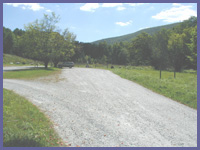
parking lot which is on
the right side after the
farm area.
Directions:
Get on Route 41
in Egremont, MA (41 heads
north out of Salisbury, CT
and south out of Egremont,
MA.). Just south of
Egremont, MA., Mt.
Washington Road is off of
Route 41 (left side of
road if you're heading
north, right side if
you're southbound). Take
Mt. Washington Road for
about 2 miles and you'll
see a green street sign on
the left side of the road
that says Jug End Road.
Take a left onto Jug End
and follow it to the
parking lot which is on
the right side after the
farm area.
You can also go to
mapquest.com and type in
Jug End Road Egremont, MA
for customized directions.
Printable
version of the Jug
End page
|