The only way to stand atop Mount
Race and take in its
sweeping views, is to hike long
and hard from somewhere...as there
are no easy routes to Mount Race.
No matter where you start, you'll
have to take on some of the
steepest parts of the Appalachian
Trail (A.T.) in the northwestern
Connecticut and southwestern
Massachusetts region. But if
you're in reasonably good hiking
shape and not in a hurry, you can
create a wonderful all day hike
that will reward you many times
over.
Besides being beyond many day
hikers ability, Mount Race is
overshadowed by many of it's
neighbors and therefore a lot of
folks who have hiked in this
region have never been there. Race
Brook Falls, Mt. Everett, Bear Mt.
(CT's highest peak), Sages Ravine,
Mt. Frissell (CT's highest point),
Mt. Washington, Jug End are some
of the more well known and
frequented nearby spots. Mount
Race can only be accessed by
passing by some of those
hikes so it's not suprising that
many hikers utter, "uh, I've had
enough...I'll try for Race another
day".
At 2,365 feet and nestled deep
within a forest ridgeline -
presenting just the sort of
thing that intrigues day hikers
- it should have been a place
notched a long time ago. But
given the effort to get there
it's understanbable how "never
been there" happens.
Thunderstorms, not yet in good
hiking shape, and a short winter
day, are legitimate reasons from
taking the journey to Mount
Race. The suggestion here isn't
that is a beast of a hike or
extremely hard but for most
hikes listed on this site it's a
challenge. But it's well worth
the effort to get there. The
views are stunning and there is
a short section of trail that is
scary...but a good scary! The
kind of spot that makes you go
"This is why I hike!". There's a
sheer drop-off of hundreds of
feet spreading out into a
massive valley scene below. The
drop-off in some sections
couldn't be more than 15 feet
from the Appalachian Tail you'll
be hiking on. It feels more like
2 or 3 feet from the drop-off,
but it's not. If you just calm
down, relax, and hike with
caution you'll see there is
plenty of trail and flat ground
to keep you tumbling down even
if you lost your balance and
fell. And a smile wide should
spread out all over your face or
perhaps you'll just stand in
awe. If you're hiking in a south
to north direction as we were,
it comes upon you suddenly after
a long forest hike so it really
sends a jolt of adrenaline
through you. The instinct is to
grab the nearest tree limb, sit
down, or yell out something
cool... or unprintable here.
It's not El Capitan, but it is
an impressive drop off and it's
the only stretch along southern
New England's Appalachian Trail
that has this type of scene. You
gotta check it out if you
haven't been.
Parking one car way up high at
the dirt parking lot for Sages
Ravine and another car all the
way down at the base of Race
Brook Falls off Route 41 in
Sheffield, Massachusetts is an
option if with small group. That
would be a hearty hike about 7
miles; 70% of it was flat or
down hill hiking with a not so
bad of a stretch to hike up to
Mount Race. It's a long day of
hiking, but plenty of rewards to
keep you energized. You'd pass
through the tumbling waters of
Sages Ravine (click
here for the Sages Ravine page),
across a quiet mountain ridge to
Bear Rock Falls and its valley
views, up to the sweeping vistas
and sheer drop off of Mount Race
plateau, and down picturesque
Race Brook Falls (click
here for Race Brook Falls page).
It
Mid-June thru early July will
bring Mountain Laurel
extravaganza. The green months
seem boundless with wildflowers,
ferns, bushes, blueberries just
budding, and hardwoods tall and
miniature, filled in a scene
Monet would certainly have
appreciated. If you have the
ability to bring two cars it's
highly recommended the option we
took - Sages Ravine to Race
Brook Falls. It's a great hike!
It's not easy...but if you take
your time, rest and listen to
your body when it's telling you
to rest, and bring at least 2
liters of water and a big lunch
with healthy snacks, you'll be
just fine. You can easily follow
the Appalachian Trail from Sages
Ravine to Mount Race then side
trail of Race Brook Falls. It
could be 4-6 hours of time for
you, depending upon your pace
and conditioning. There are
Appalachian Trail campsites off
of Sages Ravine and Bear Rock
Falls (now called Laurel Hill)
if you wanted to do an overnight
backpack. Campsites are first
come, first served (you cannot
reserve a campsite as it's open
to everyone who hikes in). If
you join the Appalachian
Mountain Club, you can reserve a
fantastic cabin near the
beginning of this hike. It's for
members only and it's the nicest
one in Connecticut I have seen.
(Follow posted instructions for
keeping food sources/scraps safe
from black bears snooping around
at night).
Here are several ways to get to
Mount Race.
Park one car in the Race Brook
Falls parking lot which off
Route 41 in Sheffield,
Massachusetts. Then drive up
Mount Washington Road which is
just a few hundred feet south of
the intersection where Route 41
and Route 23 meet in South
Egremont, Massachusetts. Head up
Mount Washington Road for 8
miles to Mount Washington State
Forest (somewhere along the way
Mount Washington Road becomes
East Street so don't be confused
if you suddenly see East Street
signs). Eventually an
intersection with an old white
church on your left presents
itself and you go straight
through the intersection. A
short distance later is Mount
Washington entrance on your
right (Note: Alander Mountain
Trail is an amazing hike to come
back to some other day at Mount
Washington parking lot). Go
passed the state forest and keep
on the same road. Soon it will
turn into a dirt road (VERY
bumpy and and extremely muddy
early spring and maybe
impassible in winter the further
in you go) and few miles later
the last remaining homes will
end as you enter into protected
forest of Mount Riga/Mount
Washington forest. After the
last house, it's a short drive
up the dirt road and you'll
notice 2 dirt parking lots on
your left. The first one has a
tiny "no parking" sign on a tree
(that's actually a picture with
tow truck pulling a car). I
can't imagine they would
actually tow anyone but I can't
ignore the sign and tell you
it's okay to park there. (The
Connecticut/Massachusetts state
border post is just before this
lot but it's hard to see.) The
next big parking area on the
left is where you want to park
and is also the trail head for
this hike. (Find other parking
if the lot is full but be sure
to pull way off the road as in
Connecticut this is road is
monitored often.) NOTE: During
winter this part of the dirt
road beyond the homes, and in
particular the CT/MA border,
could be impassable or even
closed by the state. The
Connecticut section is
definitely closed in winter to
vehicles but the parking area
for this hike even in winter
should be open no problem.
A trail head heading east into
the forest is obvious from the
parking lot. It's an old utility
road called Northwest Road (no
signs I'm aware of that tell you
the name of this trail). Most
people call this the "Sages
Ravine entrance" because Sages
Ravine is short 20 minute hike
from the parking lot. There's an
easy flat section of trail to
get you warmed up for the rest
of the hike. About a half mile,
maybe a little more, from the
parking lot the trail meets up
with the Appalachian Trail. It
would NOT be hard to walk right
over the Appalachian Trail and
into the woods, as it's a very
subtle thing here where an old
path, no longer used, gives you
the impression that you should
keep hiking straight. The fact
there are no signs (or
painted arrows) telling you
it's the A.T. doesn't help
either. But unless you're
seriously daydreaming or talking
a mile a minute and not paying
attention you should see the
A.T. crossing in a left/right
(north/south) direction. There
are some wooden planks down on
the trail you can use for
reference. Go left and follow
the WHITE hash marks of the A.T.
down to Sages Ravine (about 20
minutes from the car). [You
could go right to hop up for a
visit to Bear Mountain which is
Connecticut's highest peak. It's
about a half mile hike to Bear
Mountain's summit from this
spot. But it'
s a steep hike of about 600 or
700 feet of elevation in a very
short distance so maybe you can
come back another day and
explore Bear Mountain and the
miles of trail beyond it like
Lions Head lookout. The A.T.
here is about 1600 or 1700 feet
above sea level and Bear
Mountain is 2,316]
But going left in the direction
of Sages Ravine is a rocky but
easy hike. A short distance
later you'll notice a trail sign
that says Paradise Lane Trail
(another option for checking out
Bear Mountain some day would be
to do the Undermountain Trail of
Route 411 in Salisbury,
Connecticut up to Paradise Lane
Trail, up to Bear Mountain via
the A.T. and down the other side
of Bear to Undermountain Trail,
back to your car...VERY
difficult hike). But for this
hike, ignore Paradise Lane and
keep going down along the A.T.,
following its white hash marks.
The ravine is beautiful and it
plummets in between the
hillsides and lush forest canopy
with a near tropical floor scene
bursting with ferns. Along the
way there are campsites you can
check out if you're into camping
but otherwise just stay with the
white hash marks of the A.T.
until the very bottom of the
ravine, the A.T. crosses over
the stream to the other side (If
you do decide to camp here,
follow all instructions for
securing your food from black
bears...no need to worry about
being bothered my them but don't
give them an easy way to steal
your supplies and make a mess if
they happen to swoop by during
the night. Doing so also
protects the bears from becoming
too people friendly and ensures
their survival). If it's rained
a lot or tons of snow melt
flows, you'll get wet boots at
the bottom of Sages but most of
the time you hop and skip on
some rocks to get over with dry
feet.
From here it's about 3 miles
to Mount Race and soon the rush
and drama of Sages fades with a
beautiful hardwood forest,
peaceful and quiet, taking over
and changing the pace and feel
of the hike. Song birds and
woodpeckers will be your
companions through this stretch
with a few high pitched chirps
from chipmunks who are tipping
off your arrival to other chips.
For those of you living in
southern Connecticut, you'll
notice huge birch trees that are
no longer prevalent like they
were decades ago. Whether it's
global warming, spreading
suburbia, or other factors,
birch trees like this are rare
south of here. Eventually you'll
come upon Laurel Hills campsite
(used to be known as Bear Rock
Falls). Further up and to your
right, there are some really
nice rocky outcrops that offer
up gorgeous eastern views. It
may or may not be closed off do
to reforestation projects but if
you find a spot just be very
careful venturing over towards
where Bear Rock Falls plummets
over the mountainside. You can't
see the falls but you can get up
close to where it plummets over.
But stay away from the edge. The
thick tree tops make it seem as
though it's not a big drop off.
It is. If you fell, you'd
die...or if you survived the
fall some how they'd have to
pull off one of the most
dramatic rescue operations this
region has seen in awhile. It's
remote, dangerous (for the
rescue workers), and would take
them forever to find you...then
they'd have to figure out how to
get you out of there. So, just
sit back well away from the edge
and enjoy the views and just
listen to the waterfall rather
than going into "I have to see
this up close" mode. This one of
those spots a little kid could
just wander too close or someone
could start talking and walking
around, forget to watch where
they were and...whamo...tragedy
in a blink of an eye. This hike
is recommended because it's
fantastic and a ton of fun, but
feel an obligation to warn you
of possible danger. Don't be
scared to check this area out
but use your head and don't wind
up in the newspaper for all the
wrong reasons. The hikers I were
with had good instincts. Without
having to warn them they just
stayed well away and enjoyed the
views and shady rest among the
trees...they instinctively knew
to just enjoy it but not push
their luck. They respected the
spot and they didn't even bother
going to the edge of where the
fall plummets over. Smart.
After the Bear Rock Falls area
you just continue on towards
Mount Race along the Appalachian
Trial. The trail begins to rise
steady but it's never really
steep. It may get to you a bit
because you've been hiking for
awhile but just rest when you
need to and take it slow. You
will get a workout as you make
your way north along the
mountain ridge but it's never
more than a gradual climb. Mount
Race is different in that it
just seems to keep going up to a
summit point, then you realize
you've got more to go! It's one
of those spots where you won't
be able to say "this is the
highest point". As it rises up
notice how the trees are much
shorter in this region. They
almost look like banzai trees or
as if a gardener comes around
frequently to prune. Harsh
winters more than anything keep
these trees from getting too
big...they're wise old trees.
They know it's best to keep
things simple in order to
survive and thrive. (If you hike
in winter, you'd better know
what you're doing and dressed
with all the proper winter gear
and equipment. It can get
brutally cold with howling winds
that could put frostbite on
exposed skin. )
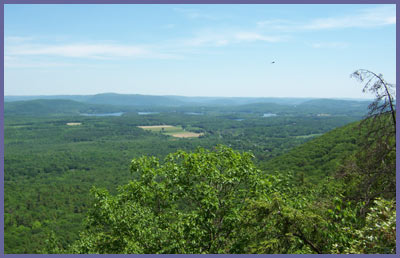
As you come closer to the top
there is a section of trail that
might really scare some people.
If you have a fear of heights
with sheer dropoffs, the trail
sort of emerges out of the woods
and suddenly into the open with
a massive drop off that's just
about 15 feet from the trail
edge. It's scary initially but
there's plenty of trail to hike
along - but if you tripped and
tumbled over, it's conceivable
that you could tumble all the
way over but even then you
should have enough buffer to
prevent falling hundreds of feet
down. But spots like this
produce a healthy fear without
terrifying - it's a fun fear!
This is one of the spots you'll
likely talk about later on when
you get back home. The views are
stunning and the drop offs give
you an adrenaline rush. For
southwestern New England, this
is about as dramatic as it gets.
There's even a large rock that
allows for the classic hiker
pose.
The trail continues to rise up
along the eastern side of the
mountain, giving up more and
more wonderful views that should
at least produce some jaw
dropping awe. Then it bends
slowly on top (look to your left
(west and southwest) and on a
clear day the Catskill rise up
high in the distance with the
Shawangunks tiny bumps way off
southwest),
then over to the northwestern
side of Mount Race before
heading back down into the
forest. Along the way a few rock
cairns (piles of manmade rock
appear and one of them marks
Mount Race's apex, though not
sure which one). On the day
these pics were taken, turkey
vultures swooped in for close
looks and a wild raven was
sunning itself on a rock...mouth
wide open for ventilation. It
looked cool and fellow hikers
got up close with their cameras.
The raven then flew off and gave
out wild yells as if to distract
us from possibly finding its
nest. Like a lot of mountaintops
around here, the hardwoods and
pines are stunted in growth. As
noted before, several look like
banzai trees...fully mature but
miniature in size. Though we
were pressed for time by the
time we reached Mount Race and
needed to continue on right
away, it's a great spot to just
chill out and take in all the
magnificent scenery and
overviews. Just rest and enjoy
your reward for hiking in so
far. This is the perfect
spot to have lunch and just
chill out from the hustle and
bustle of everyday life. You
deserve it if you've made it
this far! You've still got a lot
of trail left but the hard part
is over...though some think
coming down is just as hard as
hiking up!
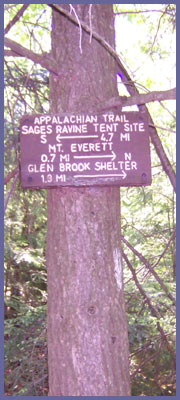
About a mile after Mount Race's
summit the A.T. meets up with
the BLUE trail markers of Race
Brook Falls. There are a couple
of trail posts within 50 feet of
each other. The second one has
more specific information and
will tell you it's 2.5 miles to
your car. If for some reason you
are feeling fantastic and not
tired after this long hike, it's
only 0.7 miles up to Mt
Everett's summit which also has
some tremendous views (the old
fire tower was taken down long
ago so you can't scramble over
the fence and illegally climb
the tower for those 360 degree
views anymore. It's a tough hike
up but only adds about 1.5 mile
round trip so if you're feeling
great, grab another mountain top
at 2,602 feet. For that you'd
continue along the white hash
marks of the Appalachian Trail
and then just come back down to
this spot the same way you hiked
up. But if you've had your fill
for the day, then turn right and
follow the blue trail markers of
Race Brook Falls.
It's a relatively short walk
through the woods until you
reach the brook that feeds Race
Brook Falls. You'll follow it
(make sure you keep your eyes on
the blue trail markers as it
would be easy to lose them
during certain spots along this
section of trail) and eventually
cross over a foot bridge and on
up to the first tier of
waterfall. The hike through this
short section is a unique blend
of dark forest and lush greens
along the forest floor. Little
bogs, streams, etc., change the
environment once again. It's
here you have a choice. If
you're tired or have had enough,
go left and follow the blue
trail markers into the woods. It
bends around the falls, crosses
at the base of the top waterfall
tier (there are three tiers),
goes back into the woods where
you'll hike all the way back to
your car hearing, but not
seeing, the two lower tiers of
the falls - they are nearly
identical to this third tier so
if you miss them you at least
have an idea of what they're
like. Another option is to hike
an inner blue trail that stays
close to the waterfall. However,
some find the blue markers hard
to spot at times and some
sections of trail might be too
steep or slippery for some. This
is potentially hazardous if
you're not familiar with the
trail system or if you're legs
are tired from a long hike but
there's no doubt it's a
thrilling hike especially if the
falls are running strong. It's a
steep drop and in certain points
a little hairy at time because
the falls cascade a few hundred
feet in about a mile. As noted,
it's also easier to loose track
of the trail markers which could
send you closer into the falls
than you wanted to go and maybe
into one of those "what do I do
know?" predicaments. It's a
gorgeous waterfall to see up
close but a few spots are
dangerous with very steep drop
offs. Advice would just be to
follow the outer/main blue trail
as it winds around the water and
back down the mountain through
the forest if you feeling tired.
This trail eventually meets up
with another trail and you take
a right where they meet for
short walk out of the forest and
to your car at the Route 41
parking lot. Or you can take a
left and hike back up a short,
and not too steep a trail, to
see the first waterfall tier.
Oh, and don't forget your
camera like I did. Fortunately,
one my hiking partners saved the
day by allowing me to use hers
and produced the photos you're
seeing on this page. This is a
photo op you wouldn't want to
miss.
Other hiking options for Mount
Race:
If you're the type that likes a
full on, "wipe me out", high
octane workout or you don't have
two cars to bring to park on
either end of the trail, you have
4 options. But...you'll need to be
in VERY good shape to attempt
these. These are long hard hikes
and you will have to turn around
and hike back so you will be out
all day. 2-3 liters of water, a
big lunch and lots of snacks, and
LOTS of time and patience. This
option is not good at all if
you're not out there hiking up
mountains all the time or not
working out at the gym getting 1-2
hours of cardio on a regular
basis.
1) Race Brook Falls to Mount
Race
The "easiest" of the hard
routes. It's not easy of course
but it is by far the shortest.
About 3 miles up to Mount Race,
and then back to your car, with
elevation gain of about 1,500
feet. The parking lot is about
700 or 800 feet above sea level
and Mount Race is 2,365 feet
high. You'll want to check out
the amazing Race Brook Falls so
follow the inner trail loops
(blue trail system with blue
marks on trees, rocks, etc) to
experience it. Or you can do the
outer loops that make it easier
to hike around the falls, but
you won't see much of it if you
take the outer loops (click
here for Race Brook Falls page).
When you've scaled the entire
waterfall, the brook flattens
out and you follow the blue
trails into the woods. A really
peaceful hike through here for
about a half mile. Eventually
the blue trails meets up with
the white trail markings of the
Appalachian Trail. Around this
area are campgrounds for
overnight camping. But if you're
not camping, you go LEFT (south)
onto the Appalachian Trail,
following the white hash marks.
You've got 1 mile of uphill
hiking to Mount Race. For this
option park at the Race Brook
Falls lot off Route 41 in
Sheffield, MA (a few miles north
over the border if you're coming
from Connecticut via Route 41).
Keep hiking on to the other side
of Mount Race for more wonderful
vistas. At the far end of this
open trail space be very
careful. If you're afraid of
sheer dropoffs, there's a
portion of trail that lasts a
few hundred yards that could be
very scary to some. If you
somehow lost your balance and
tumbled over...it could be a
loooonggg way down. So please
concentrate through this section
or just stay away from it if it
makes you nervous . However, if
you just use common sense the
trail is more than wide enough
to protect you from the edge.
It's a fun spot that will
definitely get your adrenaline
running! Round trip this hike
would be 3-5 hours depending
upon your pace.
2) Undermountain Trail to Bear
Mountain to Sages Ravine to Mount
Race
If you can do this in one day,
you're officially in great shape!
Now, some of you will take that as
a challenge to prove you are in
great shape. Please
don't...believe you...you don't
have to prove it. Otherwise, you
may underestimate this option and
really wind up regretting it if
you're not a seasoned hiker (it's
no fun being way out there with
that "I've had enough" feeling,
only to realize you've got a
mammoth hike all the way back to
the car). This is for the hard
core hiker in great cardio shape
(or of course you can camp along
the A.T. and break this into 2
days of hiking).
What a thrilling hike this is!
You'll take in some of the best
natural highlights this region has
to offer. Three miles north of
Salisbury, CT on Route 41 is the
parking lot/trail head for
Undermountain Trail. It's on your
left (on your right if you've come
from Massachusetts). From the
trail head to the Appalachian
Trail is about 2 miles and it's
another mile to Bear Mountain's
peak which is CT's highest peak at
2,316 feet. So from the parking
lot it's about 1,500 feet vertical
climb in 3 miles - this isn't a
walk in the park for the average
day hiker. This will get anyone's
blood pumping hard. From Bear
Mountain down to Sages Ravine is
another mile, then about 3 more
miles to Mount Race from Sages.
The whole hike is in the 6 to 7
mile range so that's 12-14 miles
round trip (another option for
this one would be park at
Undermountain Trail lot and
another car at Race Brook Falls
lot then you could hike beyond
Mount Race then down Race Brook
Falls). On the way back you could
bypass Bear Mountain by taking
Paradise Lane Trail and dipping
under Bear Mountain and back to
Undermountain Trail. It would take
a little distance and a few
hundred feet of elevation of the
return hike.Pack in a gallon of
water (2 liters would be really
pushing it, so more is better) and
2 large meals (trust me, you might
get hungry...twice!). Expect to
spend 5-10 hours round trip
depending upon your pace and
conditioning. Don't
do this in late fall, winter
(don't do this in winter alone
or without lot's of hiking
experience in cold weather), or
early spring. The day's are
short and it's really stupid to
hike in the dark, with cold
weather just waiting for you to
make a mistake.
Printable
version of the Mount Race
page
|