"In the woods is perpetual youth" - Emerson
|
|
|
|
Difficulty:
Strenuous, Moderate or Easy
Main
Attractions: Largest
peak in Massachusetts, fantastic
views, Appalachian Trail,
lighthouse observation deck, thick
woodlands, campsites, Bascom
Lodge.
10
day forecast
Nearby
Hikes:
The
Cascades
Snowhole
|
|
 The highest peak in Massachusetts
is Mt.
Greylock at 3,491 feet. I
guess you'll have to give this one a
go since you'll want to make the
claim that you've scaled the state's
highest peak. The views from atop
Greylock are unbelievable and you
can access those views the easy way
or the hard way. Drive up the 8 mile
road to the summit or hike a rugged
section of the Appalachian Trail all
the way to the top. Either way, you
won't be disappointed. The drive up
takes you through thick alpine
forest and eventually to fantastic
overviews of the valley below.
Hiking the Appalachian Trail here
feels more like Maine or even Alaska
if you let your imagination run wild
a bit. Black bears, bobcats, and
lynx might outnumber visitors and it
wouldn't surprise me to hear one day
that mountain lions decided to take
up residence. Don't worry, you're
chances of seeing any of these
animals are extremely remote since
they are nocturnal or wary of
people. The terrain is ideal for
providing plenty of cover and a wide
swath of uninterrupted forest. The highest peak in Massachusetts
is Mt.
Greylock at 3,491 feet. I
guess you'll have to give this one a
go since you'll want to make the
claim that you've scaled the state's
highest peak. The views from atop
Greylock are unbelievable and you
can access those views the easy way
or the hard way. Drive up the 8 mile
road to the summit or hike a rugged
section of the Appalachian Trail all
the way to the top. Either way, you
won't be disappointed. The drive up
takes you through thick alpine
forest and eventually to fantastic
overviews of the valley below.
Hiking the Appalachian Trail here
feels more like Maine or even Alaska
if you let your imagination run wild
a bit. Black bears, bobcats, and
lynx might outnumber visitors and it
wouldn't surprise me to hear one day
that mountain lions decided to take
up residence. Don't worry, you're
chances of seeing any of these
animals are extremely remote since
they are nocturnal or wary of
people. The terrain is ideal for
providing plenty of cover and a wide
swath of uninterrupted forest.
If you do decide to hike up to the
summit from the base you'll need to
be in very good shape. It would be
an all day affair even for a
seasoned hiker. If you can do it,
the rewards are great. You'll feel
like you're in the middle of nowhere
or back in the days of colonial New
England where American Indians and
European settlers met on what was
then considered the wild frontier.
Stop in at the visitors station at
the base of the reservation and grab
some maps and scout out the
surrounding trials. In addition to
an 11 mile stretch of the
Appalachian Trial, the reservation
has dozens of other trails you can
explore. Thunderbolt, Hopper, Stony
Ledge, Bellows Pipe, Mt. Prospect,
CCC Dynamite, and Bernard Farm are
the more noted trail names that lead
up part of,or all the way to the top
of, Mount Greylock. If you're leery
about hiking the whole thing but
looking for a workout, one option is
to drive up a good distance and then
hike the remaining distance to the
summit. This would be a good
alternative for those who are new to
hiking or not in tip-top shape. For
those looking for a real in-depth
hiking experience it might be best
to camp out at Mt. Greylock for a
couple of days and just wander the
50 miles of hiking trails.
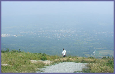
As you ascend Mt. Greylock, the
valley below gets smaller and
smaller. Some of the views are just
amazing and the surrounding towns
seem like quaint Swiss Alp villages
rather than suburban townships of
modern America. Hiking to the top
gives one a sense of real
accomplishment and the 360 degree
vistas are your well earned rewards.
North into Vermont/New Hampshire,
south into lower Mass./northern
Connecticut, east towards Boston,
west into the Adirondacks of New
York State. On a crystal clear day
you can see extremely far and
because Greylock is so much higher
than the surrounding mountains,
there is nothing to obstruct the
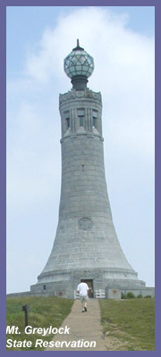
views. Mt.
Greylock State Reservation towers
over the North Adams/Pittsfield
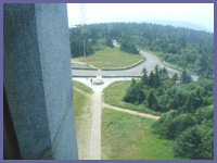
area. If the natural summit perch
wasn't enough, a 100 foot tall
lighthouse (photo is to the left)
with an observation deck seals the
deal. The War Memorial is
fascinating in and of itself and you
really should take a few moments to
read the story of how it came to be
and to appreciate the granite
inscriptions and various artwork.
People back then obviously were
proud of their service to country
and the memorial is an amazing
accomplishment that probably
couldn't be built today due to
politics and red tape. After taking
in the views, head over to Bascom
Lodge for some snacks and
relaxation. There's a dining area
with wooden chairs/tables, fireplace
with lounge chairs, and a gift shop.
The lodge was built in the 1930's
and the original rustic decor
remains. Many Appalachian Trail
hikers stay the night in the second
floor dorm rooms that are available
for a small fee. Visiting Greylock
on a clear day is key. You'd be
disappointed if the weather was
overcast.
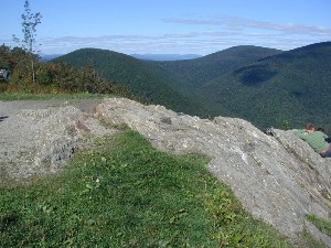 The photograph to the right here is
from a spot much lower than the
summit and it's located at the end
of Sperry Road (which is a left turn
about halfway up the Mount Greylock
summit road). It's also accessible
by hiking up the steep Stony Ledge
or Halley Farm trail system. From
this vantage point unfolds a
stunning view north into Vermont,
which is pictured here, with a
majestic close-up of Greylock to the
east - which you just have to see
for yourself! Some folks, including
one of the rangers working at Mt
Greylock, think this is the best
view in the reservation. However, if
you get a crystal clear day on top
of Mount Greylock the views can be
draw dropping. The spot where Sperry
Road ends is a great choice if the
Greylock summit road is closed and
you need to hike for views, or you
want to hike up from the valley for
a fantastic view without having to
hike the entire mountain.
The photograph to the right here is
from a spot much lower than the
summit and it's located at the end
of Sperry Road (which is a left turn
about halfway up the Mount Greylock
summit road). It's also accessible
by hiking up the steep Stony Ledge
or Halley Farm trail system. From
this vantage point unfolds a
stunning view north into Vermont,
which is pictured here, with a
majestic close-up of Greylock to the
east - which you just have to see
for yourself! Some folks, including
one of the rangers working at Mt
Greylock, think this is the best
view in the reservation. However, if
you get a crystal clear day on top
of Mount Greylock the views can be
draw dropping. The spot where Sperry
Road ends is a great choice if the
Greylock summit road is closed and
you need to hike for views, or you
want to hike up from the valley for
a fantastic view without having to
hike the entire mountain.
You can also attempt Thunderbolt
Trail as a means for
summitting Mt. Greylock. It's
extremely challenging and not for
the faint of heart. You MUST be in
very good shape to attempt it
though. Don't bother if you're new
to hiking or not in top shape. It's
vertical 2,000 feet of elevation in
about 2 miles! That's about as tough
as it gets in southwestern New
England. Contact Berkshire
Hiking if you want a guided
tour of Mount Greylock via
Thunderbolt Trail or The Appalachian
Trail.
(Interesting side note:
Herman Melville grew up in the
Pittsfield area before venturing off
on some sea adventures. He returned
to the area he loved and settled
back in. He met some new friends,
Nathaniel Hawthorne and Oliver
Wendall Holmes. They introduced him
to Monument
Mountain in Great Barrington.
Young men trying to formulate their
artist inspirations, they hung out a
lot at Monument Mountain and
inspired each other. Herman
eventually formed the idea for a new
book. From Monument Mountain, Mount
Greylock's profile looked like a
whale to Herman and it was Mount
Greylock that inspired the great
white whale he named, Moby Dick.)
 Directions: Mt.
Greylock website
These directions are taken
directly off of Massachusetts
State Parks website. Mount
Greylock is located in the
northern part of western
Massachusetts.
Directions: Mt.
Greylock website
These directions are taken
directly off of Massachusetts
State Parks website. Mount
Greylock is located in the
northern part of western
Massachusetts.
From the east or west: Take the
Mass Pike (I-90) to exit 2 in
Lee. Follow Rte. 20 west to Rte.
7 north. Continue north from
Pittsfield to Lanesborough.
About 1.5 miles north of
Lanesborough center watch for
the Mt. Greylock Reservation and
Visitor Center signs on the
right. Turn right onto North
Main St. and follow brown state
reservation signs.
From Rte. 2 in North Adams, look
for the Mt. Greylock Reservation
sign on the left, heading west;
or on the right, heading east,
just west of the downtown and
turn onto Notch Road. Follow
Notch Road 9 miles to the
summit. Phone number:
413-499-4262 or 413-499-4263
Printable
version of the Mt. Greylock page
If you have any trail updates
to share or have
feedback/questions please click
here to send email or call
203.788.7665
|
|
|
| |
All
code, graphics, multimedia, content copyright
Berkshire Hiking LLC |
|
|