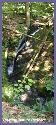
Pawling Nature Reserve is a large plot of land set aside by The Nature Conservancy right near the Pawling/Wingdale, NY line, and its western edge is near a stone's throw away from Metro North's Appalachian Trail stop. Many of you may pass its western edge frequently if you ride up and down busy Route 22 or take the Metro North train out of New York City. The Appalachian Trail runs right through the Reserve, and you can expect a very peaceful and enjoyable hike along the world-famous path. A beautiful forest hangs over the lush green canopy with some nice views along the way, and a small waterfall running through a gorge is a surprisingly treasured sight. Main roads run very close by (NY Routes 22, 55, 68), and rural neighborhoods aren't too far away. However, just like most hikes in this region, nature has a way of putting the bustle of life off and away from you, so you'll feel as though you're in a remote area. Peace and quiet that recharge the soul are easily found here.
There are over 10 miles of trails to choose from, and they are well maintained and clearly marked with various color schemes. But perhaps following the Appalachian Trail white hash marks through the heart of the Reserve and all the way out to Route 22 is the best choice if you park on the extreme eastern end of the park in its main lot. Doing so will offer a fantastic forest hike, close-up to a waterfall through a small gorge, challenging but not too strenuous uphill hiking, crossing a nice wooden footbridge spanning a small clear river, and reaching one of the nicest open field views in the area. A large sign and map at the main parking lot off Quaker Lake Road will allow you to plan out a hike that's appropriate for you. Take a good look at the map if you decide to do loops or trail sections other than the well-worn Appalachian Trail. Make sure you know where you're going and orient yourself in relation to the map before heading off. Doing so will prevent any confusion in the woods at certain trail intersections, etc. But some common sense should allow you to easily navigate any trail section you'd like to plan out and follow. It's a great place to get lost anyway!
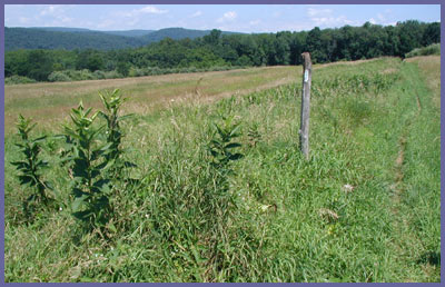
If you're into long-distance views or hiking up high, no such destination exists here. The open field view near Route 22 is a stunning open field view with nice scenic takes of mountains rolling through the valley north and south. The traffic from Route 22 is heard, especially the trucks, and some businesses and homes are seen in the distance, but mostly it feels like an old farm and fresh air. So, though you might not get those high and looking down views, the open field view is beautiful and definitely worth the hike to see it. You could also park right off Route 22 at the paved rest stops a few hundred feet up the road from the Appalachian Trail Metro North train stop. You'd walk down 22 a bit until you see the white hash marks for A.T. then hike in from there up to the field—a very short but refreshing hike. A great choice if you just wanted to stretch your legs after driving a bit along Route 22.
Most of the year, it's likely that you'll come across hikers since locals enjoy it, but it's also the Appalachian Trail. If you see someone that looks like they've been out on the trail for a while, chances are it's someone hiking the entire Appalachian Trail from Maine to Georgia or Georgia to Maine. Say hello, and many times they enjoy talking a few minutes about their life adventure. Give them a bit of "trail magic" such as an extra power bar or another tasty treat.
During the winter season, hunting is permitted to manage the wildlife within the Reserve's boundaries. You should definitely wear an orange vest and hat, though Sundays typically are "no hunting" days. Also, this is one spot that does NOT allow pets, even if they are on a leash. Please respect this wish since it's not just a local trail but an ecosystem that is fragile and trying to make a comeback in terms of flora/fauna but also its wildlife.
Visit The Nature Conservancy - Pawling page to find out official trail info and matters that concern hunting season as driving directions from their perspective.
 Directions:
You can access the Reserve two ways. The main entrance is off of Quaker Lake Road at the northeastern end of the Reserve. If you are driving north along Route 22 from the NYC/Westchester/Brewster region, follow Route 22 all the way up to Pawling until you see signs for North Quaker Lake Road (also known as Duchess Route 68 with blue street sign with "68" on top). Take a right onto North Quaker Lake Road. About a half mile up the road take a LEFT onto Quaker Lake Road. Quaker Lake Road bends and turns slowly through a neighborhood then the small body of water of Quaker Lake (private property so don't park in the town beach lot). A short distance up the road after the lake is a dirt/grassy parking area on the left for Pawling Nature Reserve. From Quaker Lake Road to the lot is 1.2 miles. If you are traveling south along Route 22, just follow the same directions except that North Quaker Lake Road will be a LEFT turn off Route 22.
Directions:
You can access the Reserve two ways. The main entrance is off of Quaker Lake Road at the northeastern end of the Reserve. If you are driving north along Route 22 from the NYC/Westchester/Brewster region, follow Route 22 all the way up to Pawling until you see signs for North Quaker Lake Road (also known as Duchess Route 68 with blue street sign with "68" on top). Take a right onto North Quaker Lake Road. About a half mile up the road take a LEFT onto Quaker Lake Road. Quaker Lake Road bends and turns slowly through a neighborhood then the small body of water of Quaker Lake (private property so don't park in the town beach lot). A short distance up the road after the lake is a dirt/grassy parking area on the left for Pawling Nature Reserve. From Quaker Lake Road to the lot is 1.2 miles. If you are traveling south along Route 22, just follow the same directions except that North Quaker Lake Road will be a LEFT turn off Route 22.
If you are traveling from Connecticut to New York via Route 55, then follow Route 55 until it crosses over into New York from Connecticut. Look for Duell Hollow Road shortly after the New York State sign (just a few hundred feet). The first road on the left is Hoyt Road, which is not what you want, but the next left off Route 55 is Duell Hollow Road. Take Duell Hollow Road and follow it as it slowly bends through the forest and rural homes, and eventually it becomes Quaker Lake Road.
An unconventional, but very cool, way to experience Pawling Nature Center would be to hop on a Metro North train out of New York City all the way to the little-known Appalachian Trail stop. It's a little wooden bench of a thing that looks like a 1920s rural America train stop. The train literally stops right on the Appalachian Trail. If you get off the train, walk up to the road (Route 22), cross the road (carefully!!! Route 22 is the main semi-highway where cars routinely drive 60 miles an hour!!!! "LOOK BOTH WAYS" has never been truer). Walk up a bit until you see the white hash marks of the Appalachian Trail and the trail itself as it disappears into a field and up towards Pawling Nature Reserve. (For a different hike, you can walk the other direction after getting off the train and eventually on up to Cat's Rock; see trail description here. From the train stop to Cat's Rock requires several miles to get there and crossing over one road after a beautiful open field hike. If you're city folk with no car and no means to get to a hike, this is a great choice for a day hike... just don't miss the train going back or it's a long walk up to Wingdale along Route 22 to catch the next train back!)
Printable
version of the Pawling Nature
Reserve page
If you have any trail updates to
share or have feedback/questions
please send
email.
|