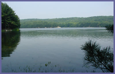
Saugatuck
Reservoir is part of the
largest protected land preserve in
southwestern Connecticut. Dozens
of miles of trails take you
through beautiful woodlands, along
shorelines, through open fields,
up rocky mountainsides with great
views, and passed some interesting
wetlands. Bobcat, lynx, coyote,
fox, deer, turkey, beaver, hawks,
eagles, falcons, possibly black
bear, and an occasional moose
habituate this area (though some
of these guys are so secretive
you're not likely to ever see
them). Watch out for the goshawks
during the summer months...they
are extremely protective of their
new borns and can become highly
aggressive! Some trails even have
signs posted warning hikers to
avoid sections altogether for
their own safety. If you see one
of those signs, don't laugh it
off. Goshawks have razor sharp
claws and have perfected the dive
bombing technique. Remember, these
signs are there to protect you,
not the goshawk!
- This feedback from a hiker
should drill the point home that
the goshawk threat is no joke:
I wish to report
an attacking goshawk on the
Saugatuck trail this morning
5/3.
there were no signs posted and
it was quite close to the
trail head near Rte. 53 on the
reservoir. It was a scary
experience being buzzed by a
large hawk.
The former Bridgeport Hydraulic
Company (now called Aquarion Water
Company), The Nature Conservancy,
Aspetuck Land Trust, and other
smaller groups have worked in
conjunction with each other to
pull off one of the greatest land
preservation acts in the history
of the state. Connecticut governor
Jodi Rell announced the
designation of the Centennial
Watershed State Forest, of which
Saugatuck Reservoir is a part of.
Real estate developers must have
cried and pounded their fists once
they learned this land would never
be developed. It's an amazing
accomplishment given that
developers have been tearing up
beautiful spots and throwing up
sub-divisions and condos at an
astounding rate...usually with
total disregard to the
environment. Consider the fact
that million dollar homes have
become the near norm in this part
of the state and it's not hard to
imagine that a handful of folks
could have made an obscene amount
of cash. See how much of the state
developers have bagged. This
map
illustrates in great detail how
much humankind dominates this part
of the state. Pretty scary. (Photo
is courtesy of The Nature
Conservancy)
They may have taken most of
it but at least there are a few
great spots that are forever safe
due to the intelligence and
determination of a few great
people who understand that
preserving certain natural spots
is simply priceless.
(Thank you to anyone responsible
for making all of this possible!)
Saugatuck and Aspetuck Reservoirs
reside in the towns of Easton,
Redding and Weston and the
watershed created by these two
bodies of water provide
interesting ecosystems for the
curious hiker.
Though not well known to the
general public, the protected
parcels of land surrounding
Saugatuck Reservoir are some of
the most pristine and
uninterrupted anywhere. Saugatuck
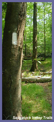
Reservoir Trails is maintained by
Connecticut Forest and Park
Association. The trails are blue
blazed. In order to hike here,
you must contact Aquarion Water
Company and have them send you a
free map of the trail system
which also doubles as your
hiking permit. www.aquarion.com
203-452-3511. You can
also grab a map at the Mark Twain
Library (www.marktwainlibrary.org)
in Redding on Rt. 53, which is
half mile north of Rt. 107. Tom
Ebersold also pointed out that you
can pick up a copy of "The Book of
Trails IV" for $10 at the library.
The book has info and maps on all
Redding trails.
Saugatuck Reservoir Trails borders
"The
Den" from The Nature Conservancy
and Trout Brook Valley. Trout
Brook Valley is managed by the
Aspetuck Land Trust (www.aspetucklandtrust.org).
Combined, you have one of the best
hiking spots in all of southern
New England...right smack in the
center of the most congested part
of Connecticut. It's easy to get
to, with trails well maintained
and clearly marked. For those
willing to venture in a variety of
terrain exists. Just don't forget
to get your free map which also
acts as your hiking permit.
Printable
version of the Saugatuck Trails
page
 Directions: There
are so many choices in this region
that picking one place to enter or
recommend doesn't really make
sense. Also in order to hike in
this region you will need to
contact the Aquarion Water Company
(formerly known as Bridgeport
Hydraulic Company and have them
mail you a free map - or pick up a
copy at the Mark Twain Library.
The map also acts as a permit
allowing you (and your group of
hikers if more than one) to
legally hike along the trail
system here. This preserve
surrounds the reservoir which
provides drinking water to many
residents. Remember that after the
events of September 11th, homeland
security is taken very seriously
by federal and state authorities.
Places like Saugatuck Reservoir
are regularly patrolled by park
officials and authorities,
especially along the shoreline. So
order the free map and put it in
your pocket when you hike around
here.
Directions: There
are so many choices in this region
that picking one place to enter or
recommend doesn't really make
sense. Also in order to hike in
this region you will need to
contact the Aquarion Water Company
(formerly known as Bridgeport
Hydraulic Company and have them
mail you a free map - or pick up a
copy at the Mark Twain Library.
The map also acts as a permit
allowing you (and your group of
hikers if more than one) to
legally hike along the trail
system here. This preserve
surrounds the reservoir which
provides drinking water to many
residents. Remember that after the
events of September 11th, homeland
security is taken very seriously
by federal and state authorities.
Places like Saugatuck Reservoir
are regularly patrolled by park
officials and authorities,
especially along the shoreline. So
order the free map and put it in
your pocket when you hike around
here.
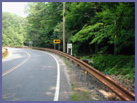
The best place to park for the
Saugatuck Trails is the gravel
parking lot at the corner of Rt.
53 and Valley Forge Road, which is
3.5 miles north of Weston Center.
Take the Merritt Pkwy. to Exit 42
and head north on Rt. 57. In
Weston Center, take Rt. 53 N. The
parking lot will be on the right.
To access the trail, walk down the
hill on Valley Forge Road for 0.15
miles. The trailheads will be on
the left to head north (the more
scenic trail with great reservoir
views) or the right to head south.
If you have any trail updates to
share or have feedback/questions
please click
here to send email or call
203.788.7665
|