|
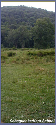
Schagticoke Mountain near Kent School is the kind of spot where you can venture off on short or long distance hikes. It's convenient, as the center of Kent is just a mile down the road. The hike at Schagticoke Mountain isn't officially named but is best identified in this manner, as the small dirt cutout along Route 341 is a few hundred feet up from Schagticoke Mountain. The trail takes you across nice open fields/farmland with wildflowers, birds of all types, cows, and along a picturesque stream bed. You can also venture off beyond the open field area and into the woods, which present semi-steep climbs offering nice overviews for those willing to break out into a good sweat.
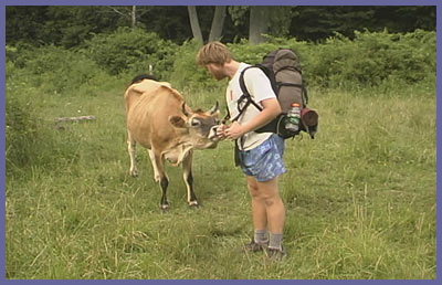
When you park in the dirt cutout you'll notice the trail head across the street (Route 341). There's a small footbridge and Appalachian Trail sign. Climb over the bridge structure and follow the trail as it makes its way through the open space area. You'll likely be greeted by some interesting hosts. The cows that feed in these fields are free to roam all over and there's a good chance that you'll have a close encounter (The picture above with the cow is of "Opie" who I ran into on the trail. He was hiking the entire 2,000 + miles of the Appalachian Trail all the way from Georgia to Maine! Hope you made it all the way to Maine, Opie). Don't worry as the cows are harmless; but if you are nervous for whatever reason just keep your distance and walk around them. The trail meanders through this field and along a small river. It eventually heads up into the woods for a short but steep climb through some dense forest and over rocky terrain.
If you want an easy hike, your best bet is to explore the open field section. It's surrounded on all sides by rolling hills; and on a sunny day the cloud formations roll through, with turkey vultures and hawks soaring and diving around. There's some nice wildflowers, tall grasses, and plenty of bushes and trees providing nice cover for all the small birds that nest and feed in this section. The stream that runs through here is so clear you can see its stony bed. Find a nice spot and watch the insects, birds, and small fish interact within their environment. If you have a camera or like to paint, you'll surely find a great scene to capture.
After relaxing in the open field section you can take on more challenging terrain by following the trail into the woods. Here the trail quickly rises and will get your blood pumping for about 15 minutes. The forest cover is thick with tall trees, and the terrain is a bit rocky at times. The trail soon flattens out along the ridge top and takes you through some quiet woodlands that most likely were pastures years and years ago. Stone fences and other tidbits of a time long gone remain and remind us that the terrain was quite different years ago. Continuing along the trail eventually presents two decent overviews looking down at Kent center. Unfortunately trees have matured to the point where they actually wind up blocking some potentially great views. Too bad years ago they didn't think of this and clear out the saplings and place some bushes in their place. These spots possibly would present the best view in all of Connecticut of a classic New England town. However, they're still nice spots to check out and the second of the two overviews is by far the best. There's a nice northeastern view of the valley below, and you can see parts of the town as it stretches along Route 7. You might be sharing this view with some turkey vultures who have the best view of all since they hang out on the branches of the trees that are blocking your view of Kent Center! If you're a hearty soul or looking for more hiking, you can continue on the Appalachian Trail. This will eventually lead you across a road and over to Caleb's Peak and St. John's Cliff. Caleb's Peak offers some really nice views east, and nearby St. John's Cliffs is a popular rock climbing spot. Going all the way over to these hikes puts the difficulty meter on "strenuous" for the typical day hiker, so bring plenty of water and energy food. Remember that you've got to turn around and go back. If you're hiking with someone else or a group, bring two vehicles and park one at Schagticoke Mountain and the other at St. John's Cliffs parking lot.
Another option at Schagticoke Mountain is to head straight up the side of Schagticoke Mountain at the dirt cutout parking lot where you park your car instead of crossing the road to Caleb's Peak. It's really steep, and your heart will be pumping hard just minutes into the hike. This also is the Appalachian Trail (heading south), and from here you can go along the ridge of Schagticoke Mountain. The ridge doesn't offer much in terms of views, but it is a nice woodland hike. You can choose to hike all the way to Bull's Bridge from here if you want a long distance hike (a nice option if you go with someone and drive separate cars; and park one at Bull's Bridge and the other at Schagticoke).
Schagticoke is the name of a group of people who recently received official tribal recognition from the U.S. government. It's a fascinating story that is quite controversial because people feel the Schagticoke are just using Indian recognition to get casinos built. I hope there's more to it than just casinos but I'm sure Schagticoke are eye-balling the possibilities (who wouldn't when you can pull in hundreds of millions of dollars every year!). It's funny how folks get angry over this and mobilize a large movement to overturn the ruling, but they could care less how real estate developers tear up the last remaining open fields, beautiful farmland, and wooded areas all over western Connecticut to build suburban sprawl, golf courses, mansions, stores, malls, etc., just so a handful people can make multi-millions. Although casinos do threaten a community with certain social diseases, what really is the big deal about a place that won't be any bigger than a high school or large mall when you compare that to all the lost colonial history, majestic trees, fascinating wildlife, and aesthetic beauty that developers have taken from this region of Connecticut? Anyway, if you wanted to see the Schagticoke compound (more like a couple of homes with a picnic bench/campsite area) head down Schagticoke Mountain. It's a winding, bumpy, dirt road that follows the Housatonic River and ends near Bull's Bridge (take a left at end of dirt road to get back to Route 7). Or visit their website to find out more about them. http://www.Schagticoketribe.com
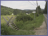 Directions: From Route 7 in Kent center, take a left onto Route 341 and head west past the Kent School and athletic fields.
A few hundred yards past the ice hockey stadium (large structure with curved roof) will be Schagticoke Mountain on your left. The dirt cutout parking area is about another 200 feet beyond the road.
Directions: From Route 7 in Kent center, take a left onto Route 341 and head west past the Kent School and athletic fields.
A few hundred yards past the ice hockey stadium (large structure with curved roof) will be Schagticoke Mountain on your left. The dirt cutout parking area is about another 200 feet beyond the road.
Printable version of the Schagticoke Mountain page
If you have any trail updates to share or have feedback/questions please click here to send email or call 203.788.7665
|