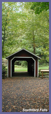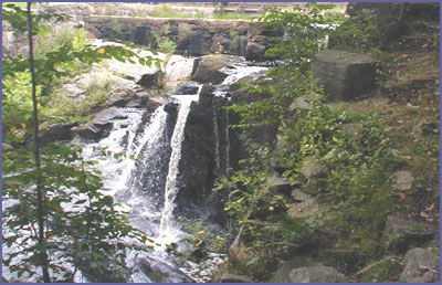
The waters that create Southford Falls in Oxford, CT, build up in Papermill Pond, tumble down large boulders to create the waterfall, then continue on through the woods as Eightmile Brook. The Larkin Bridle Trail fortunately takes you right over the pond, up close to the falls, and along the banks of the brook. It's a wonderful spot that is sure to capture the imagination of all who visit. And a small covered bridge was built to add a nice touch to the park as well as afford a unique view of the falls. Southford Falls is the kind of place where you can just get out of the car for some leg stretching or picnicking - but you can also venture off on the trail loop if you're looking for a workout, peaceful forest hike, and an observation tower that has a nice, but not great, view.
Larkin Bridle Trail is about a 2 mile loop that is flat for the most part. Red hash marks on the trees and rocks tell you where to go.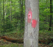 There are steep sections but they don't last long at all so anyone beyond "couch potato" mode could tackle the whole loop without too much trouble. You have two options really as far as doing the trail loop. You can go off to the left along the pond and then into the forest, or down the waterfall section first and then up into the forest. It's really a choice of whether you want to start your hike with a waterfall or end it at the waterfall. If you're not sure whether to tackle the whole trail you're best bet is to enjoy the waterfall section and then gauge if you want to go back to the car or begin the forest hike. There are steep sections but they don't last long at all so anyone beyond "couch potato" mode could tackle the whole loop without too much trouble. You have two options really as far as doing the trail loop. You can go off to the left along the pond and then into the forest, or down the waterfall section first and then up into the forest. It's really a choice of whether you want to start your hike with a waterfall or end it at the waterfall. If you're not sure whether to tackle the whole trail you're best bet is to enjoy the waterfall section and then gauge if you want to go back to the car or begin the forest hike.
I tend to think most folks will choose to explore the waterfall area first. It's a really nice spot and the trail follows the brook down into the forest. There's some nice peaceful spots at the extreme end of the brook. Route 116 traffic is prevalent but it's not too bad really. As the trail flattens out along the babbling brook you have the option of going left or straight. Continue on straight if you want to do the entire trail that includes the observation tower. But you could take a left at this point and cut through the forest for a smaller trail loop. However, I really don't see the point in that unless you're not in good shape or don't have an interest in the observation tower. So continue on along the brook and all the way past the wooden footbridge sections. Then the trail heads up towards the left and rises steadily but not steep enough to intimidate anyone. The trail begins to bend to the left (there are several spots along the trail where you need to pay attention...some spots makes it seem like you could go left or straight but always go LEFT...straight trails might be deer paths or locals making another entrance trail into the park...they are dead ends and would only add unnecessary mileage to your hike). A few small sections can be steep but they're not long so no need to worry about getting into a long difficult hike...just enough to get the blood pumping!
As you make your way to the mountain's plateau, there is a point where the trail bears sharply to the right and then left so keep an eye out for the red hash marks. As you make your way into deeper forest, the occasional car noise of 116 fades and it's amazing how quiet it can get in amongst all the tall trees. Chipmunks seem to rule the land here and there sharp chirps and calls send out warnings to fellow chipmunks that you're arriving into their world. Not long after the trail flattens out up top keep your eyes peeled for the double red hash marks and a sign that says "tower". This is a side trail off to the left that will take you to the side trail...a short hike that isn't hard at all. Soon you'll come upon the old metal tower with it's worn out wooden steps. The structure is good and sturdy but one or two steps seemed worn out so go easy on them. If you're afraid of heights, the winding up motion of the staircase is steep and takes you up fast so hold on to the railing good and tight (keep an eye on kids here if they are hiking with you...the structure is strong but I was a little surprised of how wide a space there was between the fence walling. A good sturdy grip and careful steps is what you should be reminding the little ones to do. The observation tower viewed from the ground gives the impression that you're going to have an amazing view. That might have been so decades ago when the trees were not there, or just seedlings. But the trees of today block out what could be a fantastic view (I'll never understand that. I've been to so many towers in this region where if they had just pruned out young saplings years ago and kept the grounds around the tower free of tall trees, the views would be magnificent. It's funny how parks to such a great job of caring for the lands and providing great natural resources but they fall short on things like this. I love trees too, but cutting down 10 of them isn't going to hurt anyone...people or animals...there'd be about 10 million other trees to left so wouldn't exactly be clear-cutting). As a result, the view is nice but not great (but definitely a great spot during foliage season). It's worth the trip because it's always fun to climb a tower and look out over the land. And the hike up to it is nice.
After viewing from the tower, head back to the main trail, taking a left. For the next 10 minutes or so this section of forest is great. Tall majestic trees and birds will be your companion. It's quiet and the ground is lush with green during the warm months with the occasional large boulder formations grabbing your attention. After a bit the trail begins to wind down through the forest, back towards the main area. Soon it will flatten out and take on a boggy, swampy feel. Some of the wooden planks designed to keep you feet dry seemed a little shaky but more than capable of handling your footsteps...I wouldn't jump on 'em though! As the trail leaves the forest, the far end of the main area pond greets you. Ducks, geese, and swans usually hang out here and it's not hard to get a nice view of them. Summertime, the frogs and toads will likely leap off into the water as they hear you coming. Colorful spiders and butterflies patrol the shoreline so carefull of large spider webs if you intend to investigate the pond's shoreline.
You wind up in the open field of the park with plenty of places to lie down in on the grass or picnic at one of the tables. It's a good way to end hike...relax by a picturesque pond before heading back to the car. If you're into fishing and have a license, Papermill Pond is stocked with trout and other fish to encourage folks to cast their lines and get into the sport of fishing. On some of the tree branches hanging over the pond you'll likely see more than one old line that resulted in a bad cast.
All in all, Southford Falls is a can't-miss spot. You can go wrong here if you're looking for easy access to nature and an easy going hike. Summer weekends see the most people as folks like to hang out in the main area, but crowds usually aren't bad at all. Same is true during peak foliage season. But off peak days you'll likely be there by yourself or with just a handful of people.
Visit their official website for more information
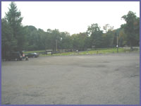 Directions: Take exit 16 off of Interstate 84. At end of ramp (whether you were traveling east or west), take a left onto Route 188. 188 heads down a short distance and joins Route 67 at traffic light. Take a left onto Route 67 for just a very short distance. At the next light (deli on your right), take a right and follow Route 188 again. Southford Falls is a ˝ mile on the left. The first entrance is for town/park workers, you need to park the next one down where the pond and footbridge are.
From Route 8 north or south: take Exit 22 onto Route 67 in Seymour. Follow Route 67 north through Oxford. After about 9 miles, take a left at the traffic light at the Junction of Route 188. Southford Falls is approximately a ˝ mile on the right.
http://dep.state.ct.us/stateparks/parks/southford.htm
Printable version of the Southford Falls page
If you have any trail updates to share or have feedback/questions please click here to send email or call 203.788.7665
|