Sunset Rock is the type of hike that allows you to hop out of the car, hike a short distance without much elevation gain, and take in sweeping views; the valley below spreads out all around and the Catskill Mountains rise up in the distance. Sunset Rock surely gets its name for the simple reason that the hike ends at a small rock facing west, which should proceed some spectacular sunsets as the day's rays disappear behind the distant Catskill Mountains. It's kind of funny though...the sign at the trail head says "Closed at sunset". How are you supposed to visit Sunset Rock at sunset if they want you out of there by then? Well, I suppose you'll be just fine if you linger on for the show but you wouldn't want to stay too long after the sun dips beneath the tall mountains anyway. Though the trail is clear and passable with ease, the forest is thick like a jungle right up close to the trail, path is quite rocky in the beginning, with small canopy overhead, so it would be a nasty spot to hike in the dark or in the twilight hours of dusk.
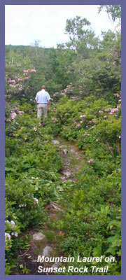
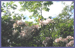
The trail is about 1.2 miles round trip so it's just a half mile to take in the views. Sunset Rock is a side trail off the much longer South Taconic Trail, and the are one most of the way until you get to a plateau clearing where they split off again. South Taconic Trail runs for about 10 miles up, down, and on top, of the Taconic Plateau - a region The Nature Conservancy has designated one of the last great places. It's not hard to see why. The hike is beautiful. It's one of those hikes where you're immediately transported into nature's world; just the new kid on the block passing through. It's classic hardwood forest mixed in with all sorts of wild bushes, ferns, flowers, and berries. But one thing you're likely to notice is how short all the trees are. Some of the birch, oak, pine look like some sort of Japanese banzai tree garden. You're just high enough (parking lot is about 1,700 feet above sea level and Sunset Rock is probably 1,850 feet) where the trees find it easier to survive being small rather than grand. If you hike in mid/late June til very early July, Mountain Laurel explodes in the forest and completely takes over. The white and pink blossoms are quite a sight to behold (see picture to the left - you can see Mountain Laurel literally showering the path with white/pink blossoms as my older brother, who introduced me to hiking many years ago, passes through).
 You want wildlife? You're in the right spot. Birds are the most obvious wild ones since you'll see (or should I say hear since they are so good at hiding in this terrain) and don't be surprised to encounter dozens within 5 minutes of your hike. Downy Woodpeckers usually clang back and forth and it's possible a Towhee will bounce along in the bush right along with, close by but never allowing you a good glimpse (visit Berkshire Hiking's bird page for pictures and bird songs). Early summer also brings wild blueberries which are a favorite of black bear. They can eat until their hearts content in this region since the forest you're hiking through is a zone of preserves involving Connecticut, Massachusetts, and New York - you're very close to the tri-state border (NOTE: It's highly unlikely you'd actually see a bear as I've been hiking nearly 25 years and never have, so there's no need to worry). You'll be hiking south through New York's Taconic State Park. To the northeast is Massachusetts' Mount Washington State Forest and to the southeast is Connecticut's Mount Riga Forest. All three zones are protected and create a magnificent corridor for nature to dominate. Therefore, black bear, coyote, fox, bobcat, lynx, and some say (though it could be just a local legend) that mountain lion have returned. Mountain lion claim aside, it's not hard to see how all the others can thrive here. It's gonna be a shame when all those farmers along Route 22 finally sell off. If you included the valley below on the New York side as part of a new National Forest, this spot would be one of the most amazing natural zones in southern New England and Hudson Valley. But I suppose 10 years from now when you look out over the view from Sunset Rock you'll see all sorts of new suburban neighborhoods plopped in there. So get there soon before the view changes too much!!
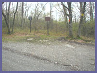
The trail begins at a dirt parking lot. You hike right in along the trail which for about 15-20 minutes is both Sunset Rock Trail and South Taconic Trail. (If you look behind and across the dirt road where you parked you'll see the white markers of South Taconic going back into the forest. It'll end a few miles north at Route 23.) A short distance later, the trail comes to a left/right decision. You want to follow the arrow pointing right. Go right, and the trail now flattens out and takes you through a scene where the hobbits of "Lord of the Rings" could call home. The thick canopy presents something unique. Because the trees grow short here and the forest is so thick, it bunches right up against and over the trail. It's as if a wealthy billionaire paid a professional landscape artist to create a grand tunnel for his daughter's wedding day...no wait...no money could buy what nature has done here. It wouldn't be possible. It's beyond cool and it's a spot where you have to stop, listen, and look. You're in a place that no longer exists in this part of the country. Humans have so dominated that they have taken over and overrun nature to the extent where things like Mountain Laurel have disappeared accept in protected places. Volunteers literally hunt down invading plants/trees that aren't natural to this region and leave what is. If you have children with you, explain to them how special a spot like this is and how it's not a coincidence that birds are bounding everyone and singing a grand tune and the trees and bushes are thriving...this is paradise for them!! No house cats, no dogs (IF YOU'RE BRINGING YOUR DOG PLEASE KEEP IT ON A LEASH AND DON'T LET IT CHASE THE ANIMALS LIKE RABBIT, CHIPMUNK, OR SQUIRREL), no lawn mowers, leaf blowers, wood chippers, pesticides to make grass greener than it should be, or suburbanites as far as the eye can see. This is their world and they thrive in it. Just check out how much there is right in front of you in such a small place. Monet would've had a field day here.
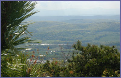
After enjoying the natural canopy/tunnel, eventually you emerge into a clearing with some obstructed but nice western views. Keep going to your RIGHT and follow that trail down - it's not steep or long so if you're a little tired keep going! (This spot could be confusing to some so just remember to go RIGHT on the way to Sunset Rock and LEFT on the way back to the car) There are other trails to the left but ignore them - unless of course you want to explore them.) Soon you'll come upon the small rock that gives up huge views. I won't bother to explain the views as that's something you should have for yourself without and preconceived notions. But it's 180 degrees of western views with the Catskill Mountains framing out the view. Enjoy.
Sunset Rock can incorporate many other sites including Bash Bish Falls. Visit there first for different trail options. They would be much harder and longer though. If you like to hike long distance and disappear for a few days into nature, visit the ranger's station at Taconic State Park or use their website to call or for maps. They could have suggestions for tackling the South Taconic Trail which would incorporate Sunset Rock, Bash Bish Falls, Mount Alander, and Brace Mountain The book, "Massachusetts and Rhode Island Trail Guide" by Appalachian Mountain Club, has a good pocket trail map of this region that folds out. You can buy it online or most bookstores are likely to carry it. For a more detailed map, you can also visit Berkshire Natural Resources Council - www.bnrc.net and purchase a great South Taconic Trail map. Click on "Maps" to see what they have in stock. If you become a member (reasonably priced) you get discounts and other things that make it a good investment since they protect areas like this region.
 Directions: To create your own custom directions and see a map, mapquest.com the following street address: 10 North Mountain Road, Copake Falls, New York. Then ZOOM IN a few times to see Sunset Rock Road.
For those coming south from Connecticut or NYC area it's best to get on Rt. 22 north as it heads up New York along the Connecticut/Massachusetts border.
Keep on Rt. 22 north and you'll eventually come to Copake, NY which is located where New York, Connecticut, and Massachusetts borders meet.
Proceed through the town of Copake and soon you'll approach the town of Copake Falls.
As you near Copake Falls, Rt. 344 east meets Rt. 22 (Saint Bridgett's Catholic Church is just before this on your right). Take a right onto Rt. 344 (east) and follow the signs for "Taconic State Park". However, instead of taking a right to go towards Taconic State Park, go straight and continue on this road as it bends to the left. A very short distance later is North Mountain Road on your right. (You could go into Taconic State Park ranger station first to get maps/info and also get supplies at corner market then head back out this way) But you follow North Mountain Road for about 1.5 miles and then Sunset Rock Road will be on your right. It's a dirt road and quite small and winding - GO SLOW. Also in winter this road may close but probably stays open to hunters, snowmobiles, etc. Anyway, one mile up Sunset Rock Road on your right will be the trail head and a small dirt parking lot (room for more than handful of cars).
If coming from New York above Copake from the north, the Rt. 344 and Rt. 22 meeting will be on your left, before Saint Bridgett's church. Take a left into 344 following signs for Bash Bish Falls and Taconic State Park...then North Mountain Road is a very short distance on your LEFT...don't worry if you miss the first turnoff into Route 344 because another one a few hundred yards later just before Saint Bridgett's church (the same one those coming from the southern direction would take.
If you're coming from Massachusetts you probably should take the Route 22 New York directions above. But you could take a right off of Route 7 in Great Barrington, Massachusetts and onto Route 23 going west. Soon you'll go through South Egremont, Massachusetts and the intersection of Route 22 and 41. Go south on Route 41 then about 100 feet...very quick so go slow...take a right onto Mount Washington Road. About 4 or 5 miles as the road rises up sharply, it flattens out (and somewhere along the way Mount Washington Road just becomes East Street...it's kind of random so don't get confused). Look for a dirt road called West Street on your right. Take West Street as it bears to the right and stays to the right again a few hundred yards later. About 1 mile, maybe less, the dirt road passes by a home and starts to go downhill. A few hundred feet on your left will be the parking area for Sunset Rock.
If you have any trail updates to share or have feedback/questions please click here to send email or call 203.788.7665
|