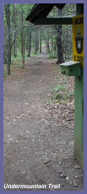
Undermountain Trail in Salisbury, CT might be the most popular starting point for hikers in the state of Connecticut. There are two main reasons for this. The community of hikers in this part of the state are hard core, dedicated hikers who enjoy the most challenging trails the state has to offer. People from out of state looking for overnight adventures on the Appalachian Trail also park here as the trail head offers a great 2 mile hike to the Appalachian Trail and numerous mountain tops and waterfalls to explore.
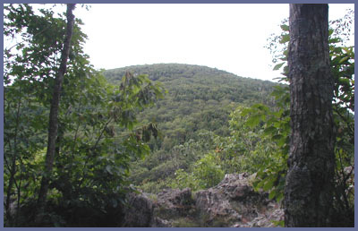
The peaks in and around Salisbury are the tallest in Connecticut. The Undermountain Trail is challenging and can be used as a day hike or jumping off point for greater excursions. This trail leads to the tallest mountains in the state. Mt. Frissell, 2,380 feet, has the highest point (it's actually on the side of the mountain a short distance from the peak which is in Massachusetts). Mt. Riga, Bear Mountain (Connecticut's tallest peak at 2,316 feet), Lion's Head, and Mt. Everett (just over the border in Massachusetts) are all within reach from Undermountain Trail. All these peaks are tough climbs. Many Appalachian Trail hikers going from Maine to Georgia have commented that the terrain in this part of Connecicut can be as challenging and picturesque as any along the Appalachian Trial. You must be in good shape to attempt even a day hike here. If you need a challenge and you're in very good condition, Undermountain and the Appalachian Trail excursions will wear you out and put a grin on your face. If you haven't done much hiking but you work out at a gym or elsewhere, come up here and take on Mother Nature's stairmaster!
Since the hikes at Undermountain aren't simple little jaunts into the woods, it's important to come prepared with plenty of water and energy food, as well as a change of clothes or extra layering. It may sound silly to prepare for a day hike that doesn't seem too bad from the road but you wouldn't want to be way out in the middle of nowhere, a long way from your car, dehydrated, hungry, and/or cold. That's a recipe for more serious problems and at the very least embarrassing memories of being caught out on a hike where you may need some help getting out. (Every year there are a couple of stories about people with hiking experience getting into a bit of trouble.) Whatever you do, don't just jump out of the car and up the trail without a backpack filled with water, food (snacks), and a layer of clothing. Also, don't start your hike too late. Let's say you look at the information board with the trail map and decide Bear Mt. would be a good destination. It's a lot farther than you think. It's steep and you'll have to come back the same way so make sure you've got the whole afternoon ahead of you. Don't start hiking up at 4:00 in the afternoon on a summer day (or 1:00 on a winter's day)!
Now that I've scared you off...be sure to check this part of the state out and use Undermountain Trail as a jumping off point. It's a great place and you'll be rewarded with waterfalls, tall mountains, and fantastic overviews with unbelievable views. The forest is thick here and of all the places in Connecticut you really get a mountainous feel here. At certain points it's hard to believe you're just a few moments removed from the quaint New England town of Salisbury. The environment along Undermountain Trail is pure outdoors! You don't have to be in awesome shape to do this hike. Just start out early, rest along the way, and be patient. You'll be really glad you ventured off.
If you feel that you're not ready for a hike such as this you can still enjoy the highlights of this region by driving up the road a few miles past the Massachusetts border. A cutoff parking lot off of Route 41 is the entrance to Race Brook Falls trail. This is a spectacular waterfall, especially after a recent rain, and the hike up to the falls is very manageable. Also, Mt. Everett has a road to the top during summer months which will allow you to take in one of the best views of the state of Connecticut. (Click the respective links for information and directions.)
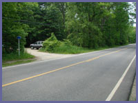
Directions: Undermountain Trail is just over 3 miles north of Salisbury center on Route 41.
There are many ways to get to Salisbury depending upon where you are coming from so your best bet is to plan a course using Mapquest to Main St. in Salisbury.
When you've made your way to Main Street Salisbury, head up to the White Hart Inn where Routes 41 and 44 intersect.
Bear left onto Route 41 north. 3.2 miles later on your left will be a dirt parking lot and the entrance to Undermountain Trail.
It's hard to miss so go slow as you approach the 3 mile mark.
Printable version of the Undermountain Trail page
If you have any trail updates to share or have feedback/questions please click here to send email or call 203.788.7665
|