Mount
Washington State Forest
sits atop the Taconic Plateau in
the town of Mount Washington, MA
right in the corner where NY, CT,
and NY meet. The western edge of
the state forest sits on the New
York border and the southern edge
borders Connecticut and its Mount
Riga State Reservation. It's about
1,000 feet above sea level, high
up over the surrounding valleys,
and may be one of the last places
in the tri-state border area of
CT, MA, and NY where you'll
experience forest as it may have
been before early Americans
leveled all trees for various
reasons over hundreds of years.
Perhaps that explains why The
Nature Conservancy has called the
surrounding area one of the last
great places and work hard, along
with local individuals and state
entities, to try and protect and
expand it as much as possible.
Nowhere in southern New England or
southeastern New York is there a
remnant of the original forest
before Europeans landed hundreds
of years ago. The original forest
was much different than the one we
see now covering the hills and
mountains. However, a "second
forest" is starting to emerge as a
magical environment all unto its
own in isolated places such as Mt.
Washington State Forest.
It's been set aside and protected
from development while logging
stopped years ago and it was a
very remote/rural spot even before
conservation efforts. As a result,
it just has a feel to it as if
it's about to become a forest
similar to the ones pre-European
settlers experienced. It's still a
baby in relative terms but it's
starting to get some real legs to
it. It's a small spot in relative
terms as unfortunately folks
didn't have the foresight to
create National Parks in southern
New England as they have done out
West. But the efforts of
individuals and small groups have
really paid off. It's a strong,
healthy forest from ground to
canopy. Hardwood trees, lush
ferns, bushes, wild flowers,
Mountain Laurel...it's green in
there during summer with colors
flashing about! Hikers aren't the
only ones to love it. Black bears
by the dozens, if not hundreds, if
you take in lands outside the
state forest boundaries. It is
highly unlikely you'd see a bear
as they are shy and/or nocturnal.
The Eastern Diamondback
Rattlesnake sunbath in certain
spots in the Taconic Plateau
region and may cross the hiking
trails while you're on them
(though just the the bear,
sightings of rattlesnakes would be
extremely rare. Lynx and bobcat
roam in stealth mode and there's a
small-scale fierce debate as to
whether mountain lion (cougar) has
made it's way back into here after
at least a century of being
missing in action. Some locals are
adamant they've seen one while
others point to "no biological
proof" of their existence. Even
the fischer has made a come back
so that all tells you how
different this spot is in
comparision to the rural but
somewhat suburban terrain
outlining this forest plateau
outpost.
Mt Washington is bounded by New
York's Taconic State Park north
and west, Connecticut's Mount Riga
Reservation south, and the
Appalachian Trail runs just to the
east of it a few ridgelines away.
Hiking up in this region is very
different from even hiking in the
rural forests 15 miles away.
There's just a different feel
altogether up here. It's not just
a conservation thing...it's also a
unique geological feature rising
1000 feet or so from the valleys
around it. It's physically
separated and if it weren't for
all the trees and rolling hills
around it, it probably would look
very similar to a rock formation
you'd see rising up off a desert
floor in Australia or Arizona.
Though northwestern Connecticut
and southwestern Massachusetts are
very rural and the least populated
areas of their state, it's still
land that is constantly changing
with farms being sold and new
development creeping in slowly but
surely. People are constantly
changing and shaping the landscape
even though it remains a really
nice region where nature seems to
dominate. This isn't true at all
in the area where Mt. Washington
State Forest lies. There is some
monitoring/maintaining of the
forest but it's more to protect it
from invasive species or for
scientific reasons more so than
constantly logging. The only way
you'll experience Mt. Washington
is if you hike into it. The only
people you'll see are other
hikers. And the trail system
allows you to not only immerse
yourself into a forest wonder with
amazing mountain views but it's in
a region where the trails link to
the trails of Mt. Riga
Reservation, the long north/south
trail of South Taconic Trail
within Taconic State Park, and the
world famous Appalachian Trail
also running north/south just a
few miles away. It wouldn't be
hard to backpack in this region,
disappear for days, and not see
many people at all nor much sign
of civilization. You can of course
just hike in for an hour and
disappear from the hustle and
bustle!
There is a large trail loop
outlining the Mount Washington
State Forest boundaries, with 4
distinct trails which allow you to
hike the entire forest zone if you
are a conditioned hiker into all
day outings. Alander Trail, Ashley
Hill Trail, Mt Frisselll Trail,
and South Taconic trail
intersection and/or join to create
the loop or allowing some
crisscrossing through the forest.
Doing the entire loop is anywhere
from 12-15 mile round trip so
perhaps the smart choice for most
is just take on Mount Alander
Trail from the ranger's station
parking lot to Alander's peak
which is about 3 miles.
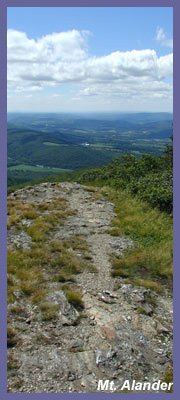
Mount Alander Trail is the main
trail leading out from the parking
lot and leads up to the stunning
views atop Mount Alander which
tops off at 2,250 feet, rising
high above the western New York
valley and offering up stunning
views in all directions. It's a
steady rise of a trail but never
very steep as the parking lot
itself is high up in the mountain
area. From Mount Alander you can
see way off west into New York
state with Catskill Mountains
rising up high in front of you and
glimpses of Adirondacks foothills
way up in the northwestern view.
Massachusetts's Berkshire
Mountains roll up north-northeast
and the tall one way off in the
distance is Mount Greylock.
Southeast views show off the last
and highest hills of Connecticut.
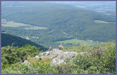
Mountain Alander is a large
plateau and not your typical peak
view where you stand and turn to
look in all directions. You can
walk up and down the South Taconic
Trail that runs right over the top
of Alander for southern views or
northern views. Most people take
just the southern views but don't
forget to follow South Taconic
Trail's white hash marks along a
tight forest trail up north to a
small clearing for views of the
Berkshires and distant Adirondacks
(see if you can spot the skyline
of Albany...hint...it's REALLY
tiny). You'll also get a grand
view from there of the Berkshire
Mountains in western Massachusetts
by looking due north and slightly
northeast. Mt Greylock is the
tallest mountain in the Berkshires
just over 3400 feet. Back at the
southern views of Alander's
plateau, Connecticut's Litchfield
Hills roll off in a southeastern
view with southwest views
presenting New York State's
Taconic State Forest in the
foreground and Columbia/Duchess
counties in the background. You
may have to hike down a bit along
South Taconic Trail to get to the
southern and western views. On
crystal clear days mountain tops
roll on for as far as the eye can
see. Alander Trail is about 3
miles from parking lot to mountain
top and takes about an hour to get
up there for most, a little more
if your pace is real easy going.
Ashley Hill Trail heads off left
(south - southwest) from Alander
Trail about a mile in. Ashley Hill
goes for miles eventually spilling
out just beyond the state forest's
boundary line almost literally on
the spot where CT/MA/NY meet where
it ends at Mt. Frissell Trail.
Frissell Trail starts back at a
dirt road (East Street) parking
area where CT/MA meet and takes
the hiker to Mt Frisselll whose
peak is in Massachusetts but holds
the highest point in the state of
Connecticut at a spot on Mount
Frissell's southern slope). Ashley
Hill Trail allows the hiker to
disappear into a forest Robin Hood
would have loved. Lush green ferns
and flora on the ground, heavy
bush cover with tall hardwood
forest canopy. You certainly will
be alone if you are hiking solo
and it's a sloppy rugged trail at
points that doesn't get a huge
amount of traffic so not a trail
for a beginner or solo hiker and
new to the area. (NOTE: Just
before Ashley Hill Trail as you
hike in on Alander Trail is
Charcoal Pit Trail. It's a short
trail that leads in to Ashley Hill
Trail before you get to the main
Ashley Hill/Mount Alander Trail
intersection. Ashley Hill Trail
has first come, first served back
country campsites. Just follow the
signs for "Camping" to get to the
campsites. Once you meet Mt
Frissell Trail via Ashley Hill
Trail you go RIGHT (west) onto Mt.
Frissell Trail for a little less
than a half a mile before taking
another RIGHT onto South Taconic
Trail as it heads north to the
peak of Mt. Alander.
GRAB A MAP ON THE INFORMATION
BOARD BEFORE VENTURING IN. YOU'LL
NEED IT especially if you try some
of the lesser used trails. It
would be easy to get lost in there
if you're not familiar with it or
don't have a good grasp of how
maps work. Even the main Mount
Alander Trail near the top can get
confusing for first timers though
most will have no problem with
that trail.
As noted Mt Frissell Trail curves
along the southern boundary of Mt.
Washington State Forest. At times
it winds in, but most of it is
just off, the forest boundary. It
dances along the CT/MA/NY borders.
Mt Frissell begins back on East
Street (same road to the entrance
to Mt Washington parking lot but
just a few miles up) just were the
state boundary marker for
Connecticut and Massachusetts
stands. Frissell trail is a red
marked trail that goes over Round
Mountain first then Mt Frissell
and eventually to South Taconic
Trail.
South Taconic Trail skirts the
western boundary of Mt. Washington
State Forest and rises right over
the top of Alander. South
Taconic Trail description can be
accessed here. It's a 12
mile long trail that encompasses
the best natural highlights in
this region (Bash
Bish Falls, Mt Alander, and
Brace
Mountain). It parallels the
Appalachian Trail which is about 7
miles to the east on the other
side of a mountain ridge. (If the
allure of the Appalachian Trail is
more your style than nearby Bear
Mountain, Sages
Ravine, and Mount
Race are amazing spots to
visit.)
The northern tip of Mt.
Washington State Forest meets Bash
Bish Falls State Park. You can
access Mount Alander from Bash
Bish but it's a steep 3.5 mile
hike in so be in very good hiking
shape and some folks claim that
trail is hard to follow at
times...and this forest isn't a
place you want to get lost so go
with a group and with at least one
person who has done the Bash Bish
to Mountain Alander hike.
Another option for hiking into
Mount Alander is via Undermountain
Road which is not far at all from
Route 22 in Copake, NY. Click
here for that option which
also gives a nice description of
the views that await you at Mount
Alander.
Berkshire Hiking offers guided
hikes in this region so don't be
shy about sending
an email and ask about rates
and availability. You can tackle
the trail yourself but if you're
new to hiking, nervous about
venturing off in an area you're
not familiar with, or just like
the idea of having a guide we have
the experience, first aid
training, and friendly demeanor to
make it worth your while.
WARNING: If you camp out over
night at the shelters observe
proper food storage etiquette.
You're in black bear country.
Although they are extremely shy
and most come out at night to
rummage for food (I have never
seen a black bear in the wild in
all my years of hiking), they are
not shy about visiting sleeping
campers who haven't stored food
properly. Visit the official
website listed below for
information on bears and how to
enjoy the forest without
encouraging bears to visit you!
Also, this region is one of the
last places in the area to have a
decent rattlesnake population.
STAY ON THE TRAILS and there won't
be a problem. I like to hike alone
but honestly for the remote
possibility of getting bitten it's
not a place to hike alone. When
visiting Alander's peak don't
venture off trail through the
grassy areas looking for your own
spot to escape to. Rattlers like
to sunbath like models vacationing
in St. Tropez! They love to chill
out in the sun and would never
attack but will bite if you step
on them or go into
Australian-tv-host snake-fan mode
and try to grab one! About 10
miles away at Bear Mountain in
Salisbury, CT a hiker was bitten
in 2006. I heard a first hand
account from a person on the scene
and the story is the hiker hiked
passed a trail he had wanted to
access and when told he had passed
it, he turned around and sort of
jogged back to make up time. A
rattler on a rock that basically
was almost on the trail saw him
coming fast and lashed out. The
first serious hiker/rattler
encounter in most people's memory.
It probably was a dry bite since
he recovered fast and was fine the
next day. Dry bites are common
since most rattlers employ it as a
"next time I'M DUMPING VENOM IN
YOU" warning. But if it's a
venomous bite then more severe
symptoms will occur the longer it
takes to get the patient to the
emergency room. If a person
completely blew off medical help
they could easily lose a leg (or
arm if that's where the bite was)
since the venom kills the cells
and it will keep spreading out if
not treated. It's highly unlikely
a bite victim would die but it's
important to get to an emergency
room as soon as you can keeping
them as immobile as possible since
it's important to keep heart rate
low in case venom was injected and
it wasn't a dry bite. Faster blood
rate means venom spreads faster
through the area so the best
immediate remedy is remain calm.
Each anti-venom shot is $1,000 (as
of 2007) and it takes up to 10
shots so you do the math. If
you're uninsured, that's coming
out of your pocket unless you
apply for some sort of financial
aid with the local hospital. All
the more reason to stay on the
trail and to simply look before
lying down in a grassy couch-like
spot off trail on the peak of
Alander. Alander sees a fair
amount of daily visitors to the
peak so rattlers don't just hang
around with hikers. They are
extremely shy and wary of people.
They run from us. Staying on trail
and using common sense will
further decrease the already
remote odds you'd be bitten.
 Directions:
The best way to get yourself there
and find updated information, such
as a map, is to visit the official
Mount Washington State Forest
website, Mount Washington State Forest
Directions:
The best way to get yourself there
and find updated information, such
as a map, is to visit the official
Mount Washington State Forest
website, Mount Washington State Forest
You can also map search
and type in Under Mountain Road,
Copake, NY. for custom directions on
how to get to Under Mountain Road
option which is on the other side of
the mountain range from where the
state forest is. There are other
options as far as hiking up Mount
Washington State Forest. One way is
to start at Bash
Bish Falls State Park and
follow the South Taconic Trail until
it meets Alander Trail. You could
also hike Mount Frissell Trail from
East Street and take South Taconic
Trail up to Mount Alander.
Printable
version of the Mount
Washington State Forest page
If you have any trail updates to
share or have feedback/questions
please click
here to send email or call
203.788.7665
|